IMAGES TAKEN NEAR TO
Cherry Garden Road, EASTBOURNE, BN20 8HF
Introduction
This page details the photographs taken nearby to Cherry Garden Road, BN20 8HF by members of the Geograph project.
The Geograph project started in 2005 with the aim of publishing, organising and preserving representative images for every square kilometre of Great Britain, Ireland and the Isle of Man.

There are currently over 7.5m images from over14,400 individuals and you can help contribute to the project by visiting https://www.geograph.org.uk
Image Map
Images are licensed for reuse under creativecommons.org/licenses/by-sa/2.0
Notes
- Clicking on the map will re-center to the selected point.
- The higher the marker number, the further away the image location is from the centre of the postcode.
Image Listing (55 Images Found)
Images are licensed for reuse under creativecommons.org/licenses/by-sa/2.0
Image
Details
Distance
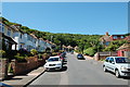
1
![Following the Jubilee Way in Eastbourne [27]](https://s2.geograph.org.uk/geophotos/07/19/54/7195422_0d831472_120x120.jpg)
Following the Jubilee Way in Eastbourne [27]
The broad path continues to contour through the woodland.
The Jubilee Way runs along the 300-foot contour of the wooded slopes of the South Downs escarpment overlooking Eastbourne. Some 6 miles long, the path runs from Willingdon through meadows and woodland to Eastbourne seafront. The path was named the Jubilee Way in 1977 in celebration of the Queen’s Silver Jubilee. Ash dieback disease has decimated the area.
Image: © Michael Dibb
Taken: 2 May 2022
0.05 miles

4
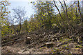
Features of woodland with ash dieback
Features of a woodland with ash dieback are dead and dying trees, tree stumps, and dead branches. These features can all be seen in the photo which was taken near Eastbourne Youth Hostel.
Image: © Adrian Diack
Taken: 21 Apr 2020
0.10 miles
5
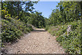
Wood chip surface along a woodland path
Wood chip has been laid on the woodland path at this point though not along the entire length of the path. The wood chippings create a more level surface for bikers and walkers while also acting to stem the flow of water and suppress weeds. The wood chips may have come from trees which had ash dieback as this area, recently, had many such trees lying at the side of the path.
Image: © Adrian Diack
Taken: 16 Jun 2020
0.10 miles
6
![Following the Jubilee Way in Eastbourne [28]](https://s0.geograph.org.uk/geophotos/07/19/54/7195424_8719652b_120x120.jpg)
Following the Jubilee Way in Eastbourne [28]
The path starts to ascend to the crossing of East Dean Road, A259.
The Jubilee Way runs along the 300-foot contour of the wooded slopes of the South Downs escarpment overlooking Eastbourne. Some 6 miles long, the path runs from Willingdon through meadows and woodland to Eastbourne seafront. The path was named the Jubilee Way in 1977 in celebration of the Queen’s Silver Jubilee. Ash dieback disease has decimated the area.
Image: © Michael Dibb
Taken: 2 May 2022
0.11 miles
7
![Following the Jubilee Way in Eastbourne [29]](https://s3.geograph.org.uk/geophotos/07/19/54/7195427_25e8b944_120x120.jpg)
Following the Jubilee Way in Eastbourne [29]
A large tank, seen from the path.
The Jubilee Way runs along the 300-foot contour of the wooded slopes of the South Downs escarpment overlooking Eastbourne. Some 6 miles long, the path runs from Willingdon through meadows and woodland to Eastbourne seafront. The path was named the Jubilee Way in 1977 in celebration of the Queen’s Silver Jubilee. Ash dieback disease has decimated the area.
Image: © Michael Dibb
Taken: 2 May 2022
0.12 miles
8
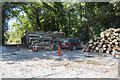
Ash dieback logs stacked in Eastbourne's Youth Hostel car park
This photo shows piles of ash dieback logs stacked in the car park outside Eastbourne's Youth Hostel on East Dean Road. Diseased trees are being removed from beside the path in the distance.
Image: © Adrian Diack
Taken: 30 May 2020
0.12 miles
9
![Following the Jubilee Way in Eastbourne [31]](https://s0.geograph.org.uk/geophotos/07/19/54/7195436_26f1f6e1_120x120.jpg)
Following the Jubilee Way in Eastbourne [31]
A youth hostel alongside East Dean Road, A259, at the point where the Jubilee Way crosses the road.
The Jubilee Way runs along the 300-foot contour of the wooded slopes of the South Downs escarpment overlooking Eastbourne. Some 6 miles long, the path runs from Willingdon through meadows and woodland to Eastbourne seafront. The path was named the Jubilee Way in 1977 in celebration of the Queen’s Silver Jubilee. Ash dieback disease has decimated the area.
Image: © Michael Dibb
Taken: 2 May 2022
0.13 miles
10
![Following the Jubilee Way in Eastbourne [30]](https://s3.geograph.org.uk/geophotos/07/19/54/7195431_e200d7df_120x120.jpg)
Following the Jubilee Way in Eastbourne [30]
Information on ash dieback. The notice is where the path crosses East Dean Road, A259.
The Jubilee Way runs along the 300-foot contour of the wooded slopes of the South Downs escarpment overlooking Eastbourne. Some 6 miles long, the path runs from Willingdon through meadows and woodland to Eastbourne seafront. The path was named the Jubilee Way in 1977 in celebration of the Queen’s Silver Jubilee. Ash dieback disease has decimated the area.
Image: © Michael Dibb
Taken: 2 May 2022
0.13 miles