IMAGES TAKEN NEAR TO
Alfriston Close, EASTBOURNE, BN20 8DN
Introduction
This page details the photographs taken nearby to Alfriston Close, BN20 8DN by members of the Geograph project.
The Geograph project started in 2005 with the aim of publishing, organising and preserving representative images for every square kilometre of Great Britain, Ireland and the Isle of Man.

There are currently over 7.5m images from over14,400 individuals and you can help contribute to the project by visiting https://www.geograph.org.uk
Image Map
Images are licensed for reuse under creativecommons.org/licenses/by-sa/2.0
Notes
- Clicking on the map will re-center to the selected point.
- The higher the marker number, the further away the image location is from the centre of the postcode.
Image Listing (20 Images Found)
Images are licensed for reuse under creativecommons.org/licenses/by-sa/2.0
Image
Details
Distance
1
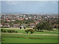
Eastbourne suburbs
Looking from The Links golf club over Eastbourne Old Town area towards the town centre and coast.
Image: © Oast House Archive
Taken: 13 Sep 2011
0.05 miles
2
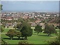
Eastbourne roof scene
Looking from a footpath on the edge of The Links golf course.
Image: © Oast House Archive
Taken: 13 Sep 2011
0.07 miles
3
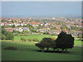
Eastbourne suburbs
Looking from The Links golf club over Eastbourne Old Town area.
Image: © Oast House Archive
Taken: 13 Sep 2011
0.09 miles
5
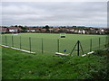
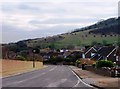
Playing Fields at Compton Drive
Viewed from the public footpath through the golf course.
Image: © Ian Paterson
Taken: 15 Nov 2008
0.12 miles
8
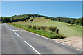
Part of Eastbourne Golf Course
Off Paradise Drive.
Image: © Julian P Guffogg
Taken: 24 Jul 2012
0.16 miles
9
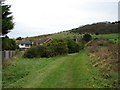
Public Footpath Near Royal Eastbourne Golf Club
Note the curved ditch meandering up the slope and bearing right.
Image: © Ian Paterson
Taken: 15 Nov 2008
0.17 miles
10
![Following the Jubilee Way in Eastbourne [40]](https://s2.geograph.org.uk/geophotos/07/19/54/7195454_ec4c1c17_120x120.jpg)
Following the Jubilee Way in Eastbourne [40]
The view from the path, looking over the course of the Royal Eastbourne Golf Club.
The Jubilee Way runs along the 300-foot contour of the wooded slopes of the South Downs escarpment overlooking Eastbourne. Some 6 miles long, the path runs from Willingdon through meadows and woodland to Eastbourne seafront. The path was named the Jubilee Way in 1977 in celebration of the Queen’s Silver Jubilee. Ash dieback disease has decimated the area.
Image: © Michael Dibb
Taken: 2 May 2022
0.19 miles