IMAGES TAKEN NEAR TO
Vicarage Road, EASTBOURNE, BN20 8AT
Introduction
This page details the photographs taken nearby to Vicarage Road, BN20 8AT by members of the Geograph project.
The Geograph project started in 2005 with the aim of publishing, organising and preserving representative images for every square kilometre of Great Britain, Ireland and the Isle of Man.

There are currently over 7.5m images from over14,400 individuals and you can help contribute to the project by visiting https://www.geograph.org.uk
Image Map
Images are licensed for reuse under creativecommons.org/licenses/by-sa/2.0
Notes
- Clicking on the map will re-center to the selected point.
- The higher the marker number, the further away the image location is from the centre of the postcode.
Image Listing (285 Images Found)
Images are licensed for reuse under creativecommons.org/licenses/by-sa/2.0
Image
Details
Distance
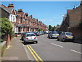
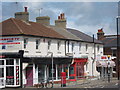
1
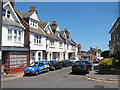
Brightland Road
Terrace of three storey houses on the edge of the Old Town.
Image: © Oast House Archive
Taken: 4 Jul 2011
0.02 miles
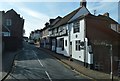
2
Vicarage Road
End of house and former shop unit of Brightland Road to right. Church Street ahead.
Image: © Oast House Archive
Taken: 4 Jul 2011
0.03 miles
4
Greys Road
Terrace of two storey houses on the edge of the Old Town.
Image: © Oast House Archive
Taken: 4 Jul 2011
0.03 miles
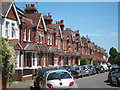
5
Greys Road
Terrace of two storey houses on the edge of the Old Town.
Image: © Oast House Archive
Taken: 4 Jul 2011
0.03 miles
6
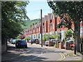
Vicarage Drive
Semi detached houses on the edge of the Old Town.
Image: © Oast House Archive
Taken: 4 Jul 2011
0.06 miles
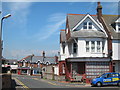
7
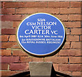
Blue Plaque VC Memorial in Greys Road Eastbourne
Blue Plaque on the north side of Greys Road, Eastbourne, Sussex. Company Sergeant Major Nelson Victor CARTER of the Royal Sussex Regiment was killed on 30th June 1916 at the Boars Head Line, Richeboug l'Avoue in Northern France. He led an assault on enemy lines and captured a machine-gun post but was killed whilst carrying a wounded man to safety.
Image: © Kevin Gordon
Taken: 4 Aug 2007
0.06 miles
8
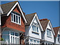
Vicarage Road roof close up
Terrace of three storey houses on the edge of the Old Town.
Image: © Oast House Archive
Taken: 4 Jul 2011
0.06 miles
10
![Eastbourne buildings [63]](https://s1.geograph.org.uk/geophotos/07/22/02/7220221_b7b0caed_120x120.jpg)
Eastbourne buildings [63]
Now converted into a dwelling, Pillory Barn in Bradford Street is dated 1813. Constructed of cobbles with dressings and quoins under a tile roof. Listed, grade II, with details at: https://historicengland.org.uk/listing/the-list/list-entry/1043668
Eastbourne is a town and seaside resort on the south coast of East Sussex, some 54 miles south of London and about 19 miles east of Brighton. Although there is evidence of settlement from the Stone Age onwards, Eastbourne remained an area of small rural settlements until the railway arrived in 1849. A resort, built "for gentlemen by gentlemen", was planned and the town's growth accelerated from a population of less than 4,000 in 1851 to nearly 35,000 by 1891. Tourism is a large and important part of the economy of the town.
Image: © Michael Dibb
Taken: 9 May 2022
0.07 miles