IMAGES TAKEN NEAR TO
Baslow Road, EASTBOURNE, BN20 7UL
Introduction
This page details the photographs taken nearby to Baslow Road, BN20 7UL by members of the Geograph project.
The Geograph project started in 2005 with the aim of publishing, organising and preserving representative images for every square kilometre of Great Britain, Ireland and the Isle of Man.

There are currently over 7.5m images from over14,400 individuals and you can help contribute to the project by visiting https://www.geograph.org.uk
Image Map
Images are licensed for reuse under creativecommons.org/licenses/by-sa/2.0
Notes
- Clicking on the map will re-center to the selected point.
- The higher the marker number, the further away the image location is from the centre of the postcode.
Image Listing (66 Images Found)
Images are licensed for reuse under creativecommons.org/licenses/by-sa/2.0
Image
Details
Distance
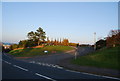
1

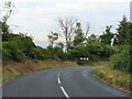
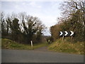
Bend on Junction of Upper Duke's Road with Baslow Road
One of several sharp bends as the road climbs up to the downs.
Image: © Julian P Guffogg
Taken: 16 Mar 2012
0.07 miles
3
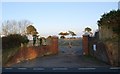
Entrance to Covered reservoirs, Beachy Head Rd
Image: © N Chadwick
Taken: 12 Apr 2010
0.08 miles
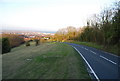
4
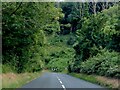
The B1023 heading down into Eastbourne
Image: © Steve Daniels
Taken: 10 Jul 2023
0.08 miles
5
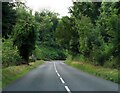
The B1023 heading down into Eastbourne
Image: © Steve Daniels
Taken: 10 Jul 2023
0.08 miles
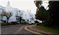
6
Path off Duke's Drive, Eastbourne
Leading to Beachy Head Road
Image: © David Howard
Taken: 3 Apr 2016
0.09 miles
9
Dropping into Eastbourne, Beachy Head Rd
Image: © N Chadwick
Taken: 12 Apr 2010
0.11 miles
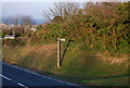
10
Meads Brow off Beachy Head Rd
An estate road on the edge of Eastbourne.
Image: © N Chadwick
Taken: 12 Apr 2010
0.11 miles