IMAGES TAKEN NEAR TO
Beachy Head Road, EASTBOURNE, BN20 7UE
Introduction
This page details the photographs taken nearby to Beachy Head Road, BN20 7UE by members of the Geograph project.
The Geograph project started in 2005 with the aim of publishing, organising and preserving representative images for every square kilometre of Great Britain, Ireland and the Isle of Man.

There are currently over 7.5m images from over14,400 individuals and you can help contribute to the project by visiting https://www.geograph.org.uk
Image Map
Images are licensed for reuse under creativecommons.org/licenses/by-sa/2.0
Notes
- Clicking on the map will re-center to the selected point.
- The higher the marker number, the further away the image location is from the centre of the postcode.
Image Listing (81 Images Found)
Images are licensed for reuse under creativecommons.org/licenses/by-sa/2.0
Image
Details
Distance
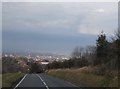
1
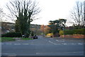
Carlisle Rd
Suburban road on the edge of Eastbourne.
Image: © N Chadwick
Taken: 12 Apr 2010
0.03 miles
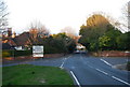
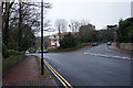
3

Salisbury Road
Off Carlisle Road, Eastbourne.
Image: © Ian S
Taken: 24 Jan 2016
0.06 miles

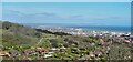
7
View across Eastbourne from Beachy Head Road
Image: © David Howard
Taken: 3 Apr 2016
0.09 miles
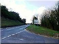
8
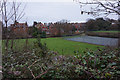
Moira House Sports Ground
On Carlisle Road, Eastbourne.
Image: © Ian S
Taken: 24 Jan 2016
0.10 miles
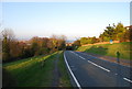
10
View towards Eastbourne and Pevensey Bay from the South Downs Way
The distant headland (beyond Hastings) is about 30 km away.
Image: © Ian Hawfinch
Taken: 25 Apr 2021
0.12 miles