IMAGES TAKEN NEAR TO
Meads Street, EASTBOURNE, BN20 7RN
Introduction
This page details the photographs taken nearby to Meads Street, BN20 7RN by members of the Geograph project.
The Geograph project started in 2005 with the aim of publishing, organising and preserving representative images for every square kilometre of Great Britain, Ireland and the Isle of Man.

There are currently over 7.5m images from over14,400 individuals and you can help contribute to the project by visiting https://www.geograph.org.uk
Image Map
Images are licensed for reuse under creativecommons.org/licenses/by-sa/2.0
Notes
- Clicking on the map will re-center to the selected point.
- The higher the marker number, the further away the image location is from the centre of the postcode.
Image Listing (200 Images Found)
Images are licensed for reuse under creativecommons.org/licenses/by-sa/2.0
Image
Details
Distance

2
Chapel, St Andrew's School
A Cof E, co-education independent prep school.
Image: © N Chadwick
Taken: 12 Apr 2010
0.04 miles
3

St Andrew's Prep School
On Darley Road, Eastbourne.
Image: © Ian S
Taken: 24 Jan 2016
0.04 miles
4
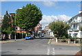
Corner of Meads Street and Darley Road
Looking towards Meads village. Taken in 2007 - there is now a new block of flats on the left.
Image: © Simon Evers
Taken: 22 Aug 2007
0.05 miles
5
St Andrew's School, Darley Rd
A co-education, independent preparatory school, run by the Church of England.
Image: © N Chadwick
Taken: 12 Apr 2010
0.05 miles
6
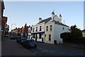
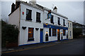
The Ship Inn, Mead St
Village type pub in the Meads area of town. In the CAMRA good beer guide.
Image: © N Chadwick
Taken: 12 Apr 2010
0.06 miles
7
![Eastbourne buildings [49]](https://s0.geograph.org.uk/geophotos/07/21/82/7218276_947054f0_120x120.jpg)
Eastbourne buildings [49]
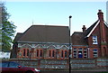
This large building in Darley Road was built as a convalescent hospital by the Anglican order of All Saints' Sisters of the Poor and converted into apartments in 2008. Built between 1867 and 1874 there is a central portion of 4 bays with two wings each of 7 bays. Constructed of brown brick with stone dressings under tile roofs. The attached hospital chapel built in 1874 has a fine and unaltered complete High Victorian interior with polychromatic brickwork. There are other views of the buildings at Image, Image and Image Listed, grade II*, with details at: https://historicengland.org.uk/listing/the-list/list-entry/1043617
Eastbourne is a town and seaside resort on the south coast of East Sussex, some 54 miles south of London and about 19 miles east of Brighton. Although there is evidence of settlement from the Stone Age onwards, Eastbourne remained an area of small rural settlements until the railway arrived in 1849. A resort, built "for gentlemen by gentlemen", was planned and the town's growth accelerated from a population of less than 4,000 in 1851 to nearly 35,000 by 1891. Tourism is a large and important part of the economy of the town.
Image: © Michael Dibb
Taken: 11 May 2022
0.07 miles
8
![Eastbourne buildings [50]](https://s1.geograph.org.uk/geophotos/07/21/82/7218277_d517c324_120x120.jpg)
Eastbourne buildings [50]
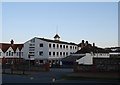
This large building in Darley Road was built as a convalescent hospital by the Anglican order of All Saints' Sisters of the Poor and converted into apartments in 2008. Built between 1867 and 1874 there is a central portion of 4 bays with two wings each of 7 bays. Constructed of brown brick with stone dressings under tile roofs. The attached hospital chapel built in 1874 has a fine and unaltered complete High Victorian interior with polychromatic brickwork. There are other views of the buildings at Image, Image and Image Listed, grade II*, with details at: https://historicengland.org.uk/listing/the-list/list-entry/1043617
Eastbourne is a town and seaside resort on the south coast of East Sussex, some 54 miles south of London and about 19 miles east of Brighton. Although there is evidence of settlement from the Stone Age onwards, Eastbourne remained an area of small rural settlements until the railway arrived in 1849. A resort, built "for gentlemen by gentlemen", was planned and the town's growth accelerated from a population of less than 4,000 in 1851 to nearly 35,000 by 1891. Tourism is a large and important part of the economy of the town.
Image: © Michael Dibb
Taken: 11 May 2022
0.07 miles
9
The Ship Inn
On Meads Street, Meads, Eastbourne. http://www.geograph.org.uk/photo/4808728
Image: © Ian S
Taken: 24 Jan 2016
0.08 miles
10

The Ship Inn
On Meads Street, Meads, Eastbourne. http://www.geograph.org.uk/photo/4808726
Image: © Ian S
Taken: 24 Jan 2016
0.08 miles