IMAGES TAKEN NEAR TO
Meads Street, EASTBOURNE, BN20 7RG
Introduction
This page details the photographs taken nearby to Meads Street, BN20 7RG by members of the Geograph project.
The Geograph project started in 2005 with the aim of publishing, organising and preserving representative images for every square kilometre of Great Britain, Ireland and the Isle of Man.

There are currently over 7.5m images from over14,400 individuals and you can help contribute to the project by visiting https://www.geograph.org.uk
Image Map
Images are licensed for reuse under creativecommons.org/licenses/by-sa/2.0
Notes
- Clicking on the map will re-center to the selected point.
- The higher the marker number, the further away the image location is from the centre of the postcode.
Image Listing (123 Images Found)
Images are licensed for reuse under creativecommons.org/licenses/by-sa/2.0
Image
Details
Distance
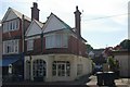
2
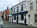
The Ship Inn, Meads Village, Eastbourne
Image: © Bard O Haland
Taken: 28 Jan 2008
0.01 miles


7
Eastbourne old fire station 2
Eastbourne old fire station 2, 48 Meads Street, Eastbourne, East Sussex
Image: © Kevin Hale
Taken: 28 Jun 2010
0.02 miles


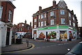
10
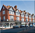
Shopping parade, Meads Village, Eastbourne
The buildings of Meads Village are extensively described at this http://www.lewes-eastbourne.gov.uk/_resources/assets/inline/full/0/259111.pdf.
Image: © Jim Osley
Taken: 21 Apr 2018
0.03 miles