IMAGES TAKEN NEAR TO
Meads Road, EASTBOURNE, BN20 7QL
Introduction
This page details the photographs taken nearby to Meads Road, BN20 7QL by members of the Geograph project.
The Geograph project started in 2005 with the aim of publishing, organising and preserving representative images for every square kilometre of Great Britain, Ireland and the Isle of Man.

There are currently over 7.5m images from over14,400 individuals and you can help contribute to the project by visiting https://www.geograph.org.uk
Image Map
Images are licensed for reuse under creativecommons.org/licenses/by-sa/2.0
Notes
- Clicking on the map will re-center to the selected point.
- The higher the marker number, the further away the image location is from the centre of the postcode.
Image Listing (101 Images Found)
Images are licensed for reuse under creativecommons.org/licenses/by-sa/2.0
Image
Details
Distance
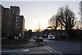
2
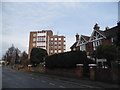
Meads Road, Eastbourne
There was a large tree outside the houses in the Google capture in 2012, obviously it is no longer there or the small one next to it.
Image: © David Howard
Taken: 3 Apr 2016
0.01 miles


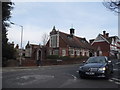
6
St John's Church Parish Hall
On Meads Road, Eastbourne.
Image: © Ian S
Taken: 24 Jan 2016
0.03 miles


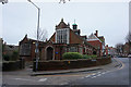
10
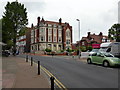
NatWest Bank, Meads Village
The bank is soon to be closed.
Image: © PAUL FARMER
Taken: 3 Jun 2014
0.06 miles