IMAGES TAKEN NEAR TO
Chesterfield Road, EASTBOURNE, BN20 7NU
Introduction
This page details the photographs taken nearby to Chesterfield Road, BN20 7NU by members of the Geograph project.
The Geograph project started in 2005 with the aim of publishing, organising and preserving representative images for every square kilometre of Great Britain, Ireland and the Isle of Man.

There are currently over 7.5m images from over14,400 individuals and you can help contribute to the project by visiting https://www.geograph.org.uk
Image Map
Images are licensed for reuse under creativecommons.org/licenses/by-sa/2.0
Notes
- Clicking on the map will re-center to the selected point.
- The higher the marker number, the further away the image location is from the centre of the postcode.
Image Listing (191 Images Found)
Images are licensed for reuse under creativecommons.org/licenses/by-sa/2.0
Image
Details
Distance
1
![Eastbourne houses [29]](https://s0.geograph.org.uk/geophotos/07/21/82/7218284_e416df46_120x120.jpg)
Eastbourne houses [29]
Hodeslea, number 10 Staveley Road, is a red brick villa built in 1890 for Thomas Huxley. Listed, for historical reasons, grade II, with details at: https://historicengland.org.uk/listing/the-list/list-entry/1293707
Eastbourne is a town and seaside resort on the south coast of East Sussex, some 54 miles south of London and about 19 miles east of Brighton. Although there is evidence of settlement from the Stone Age onwards, Eastbourne remained an area of small rural settlements until the railway arrived in 1849. A resort, built "for gentlemen by gentlemen", was planned and the town's growth accelerated from a population of less than 4,000 in 1851 to nearly 35,000 by 1891. Tourism is a large and important part of the economy of the town.
Image: © Michael Dibb
Taken: 11 May 2022
0.07 miles

3
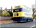
Eastbourne bus, King Edward's Parade
Buses in the blue and cream colours could be found until recently when the council ran its own bus services. However, these were taken over by Stagecoach a few years ago and the colours are now only seen on preserved examples such as this that run on Bank Holiday weekends.
Image: © nick macneill
Taken: 5 May 2012
0.09 miles
4
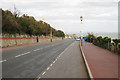
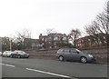
King Edward's Parade, Eastbourne
Image: © Oast House Archive
Taken: 14 Mar 2009
0.10 miles
5
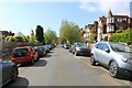
Milnthorpe Road, Eastbourne, where Sir Ernest Shackleton lived
The photo shows a southerly view of Milnthorpe Road in Eastbourne as viewed from near its junction with Chesterfield Road. Sir Ernest Shackleton stayed at 14 Minlthorpe Road between 1916 and 1922 (though he was often away in Antarctica), while George Mallory boarded at Glengorse Preparatory School on Chesterfield Road between 1896 and 1900. Although these two famous explorers and adventurers would not have known each other at that time, each went on to achieve world acclaim and near-mythic status. Shackleton, who led three British expeditions to the Antarctic, was one of the main figures of the period known as the Heroic Age of Antarctic Exploration, while Mallory’s three British expeditions to Mt. Everest are of similar status in the field of human endeavour and achievement. While pursuing the limits of what was possible, both men died young in the places they loved, with Shackleton dying at the age of 47 and Mallory dying a few days short of his 38th birthday.
Image: © Andrew Diack
Taken: 29 Apr 2024
0.10 miles
8
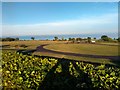
Coming down off Beachy Head into Eastbourne
The end of the 100 or so miles of the South Downs Way at the pier, seen here from almost at the foot of the last last hill of the journey from Winchester
Image: © Alan Rolfe
Taken: 17 Jul 2005
0.11 miles