IMAGES TAKEN NEAR TO
Bolsover Road, EASTBOURNE, BN20 7JF
Introduction
This page details the photographs taken nearby to Bolsover Road, BN20 7JF by members of the Geograph project.
The Geograph project started in 2005 with the aim of publishing, organising and preserving representative images for every square kilometre of Great Britain, Ireland and the Isle of Man.

There are currently over 7.5m images from over14,400 individuals and you can help contribute to the project by visiting https://www.geograph.org.uk
Image Map
Images are licensed for reuse under creativecommons.org/licenses/by-sa/2.0
Notes
- Clicking on the map will re-center to the selected point.
- The higher the marker number, the further away the image location is from the centre of the postcode.
Image Listing (107 Images Found)
Images are licensed for reuse under creativecommons.org/licenses/by-sa/2.0
Image
Details
Distance
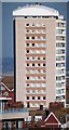
4

South Cliff Tower, Eastbourne
Built in the mid-1960s.
Image: © Jim Osley
Taken: 21 Apr 2018
0.08 miles
6
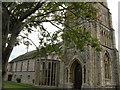
St John the Evangelist
Parish church of Meads Eastbourne.
Image: © Dave Spicer
Taken: 18 Sep 2013
0.08 miles
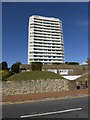
7
Tower block on Bolsover Road
18 Storey apartment block on Bolsover Road.
Image: © Oast House Archive
Taken: 2 Feb 2012
0.08 miles
8
South Cliff Tower, Bolsover Road, Eastbourne
Image: © PAUL FARMER
Taken: 6 Oct 2013
0.08 miles
10

Flats in Eastbourne
This block of flats dominates most views near the sea front. In fact, the block is visible from more than a mile away! Pictured from Duke's Drive.
Image: © Peter Trimming
Taken: 28 Jan 2010
0.09 miles