IMAGES TAKEN NEAR TO
Grassington Road, EASTBOURNE, BN20 7BP
Introduction
This page details the photographs taken nearby to Grassington Road, BN20 7BP by members of the Geograph project.
The Geograph project started in 2005 with the aim of publishing, organising and preserving representative images for every square kilometre of Great Britain, Ireland and the Isle of Man.

There are currently over 7.5m images from over14,400 individuals and you can help contribute to the project by visiting https://www.geograph.org.uk
Image Map
Images are licensed for reuse under creativecommons.org/licenses/by-sa/2.0
Notes
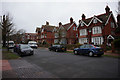
- Clicking on the map will re-center to the selected point.
- The higher the marker number, the further away the image location is from the centre of the postcode.
Image Listing (184 Images Found)
Images are licensed for reuse under creativecommons.org/licenses/by-sa/2.0
Image
Details
Distance
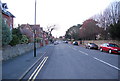
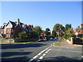
2
Grassington Road, Eastbourne
Grassington Road at the point where it crosses Carlisle Road.
Image: © Chris Heaton
Taken: 15 May 2012
0.04 miles
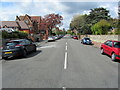
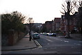
4
Junction of Grassington and Blackwater Roads, Eastbourne
Image: © PAUL FARMER
Taken: 6 Oct 2013
0.06 miles
6

Georgian postbox on Carlisle Road
At the junction with Grassington Road, Eastbourne.
Image: © Ian S
Taken: 24 Jan 2016
0.07 miles
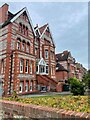
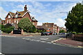
9
Blackwater Rd looking west
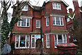
An area of Edwardian housing.
Image: © N Chadwick
Taken: 12 Apr 2010
0.08 miles
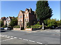
10
Caroline Ansell's Campaign Centre
On Carlisle Road, Eastbourne.
Image: © Ian S
Taken: 24 Jan 2016
0.08 miles