IMAGES TAKEN NEAR TO
South Cliff, EASTBOURNE, BN20 7AG
Introduction
This page details the photographs taken nearby to South Cliff, BN20 7AG by members of the Geograph project.
The Geograph project started in 2005 with the aim of publishing, organising and preserving representative images for every square kilometre of Great Britain, Ireland and the Isle of Man.

There are currently over 7.5m images from over14,400 individuals and you can help contribute to the project by visiting https://www.geograph.org.uk
Image Map
Images are licensed for reuse under creativecommons.org/licenses/by-sa/2.0
Notes
- Clicking on the map will re-center to the selected point.
- The higher the marker number, the further away the image location is from the centre of the postcode.
Image Listing (228 Images Found)
Images are licensed for reuse under creativecommons.org/licenses/by-sa/2.0
Image
Details
Distance

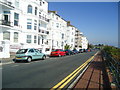
2
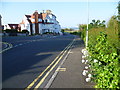
South Cliff, Eastbourne
South Cliff runs parallel to and slightly above King Edward's Parade. The junction ahead is with St John's Road and South Cliff Avenue. The Martello Tower can be seen in the distance.
Image: © Marathon
Taken: 10 Jun 2015
0.02 miles
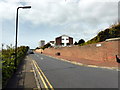
4
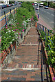
Steps from South Cliff to King Edward's Parade, Eastbourne
Image: © Robin Webster
Taken: 12 Jun 2010
0.03 miles
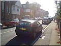
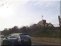
8
South Cliff, Eastbourne
Parallel with King Edward's Parade, the B2103 coast road.
Image: © Jonathan Billinger
Taken: 7 Jul 2015
0.05 miles