IMAGES TAKEN NEAR TO
Sussex Gardens, EASTBOURNE, BN20 0JF
Introduction
This page details the photographs taken nearby to Sussex Gardens, BN20 0JF by members of the Geograph project.
The Geograph project started in 2005 with the aim of publishing, organising and preserving representative images for every square kilometre of Great Britain, Ireland and the Isle of Man.

There are currently over 7.5m images from over14,400 individuals and you can help contribute to the project by visiting https://www.geograph.org.uk
Image Map
Images are licensed for reuse under creativecommons.org/licenses/by-sa/2.0
Notes
- Clicking on the map will re-center to the selected point.
- The higher the marker number, the further away the image location is from the centre of the postcode.
Image Listing (91 Images Found)
Images are licensed for reuse under creativecommons.org/licenses/by-sa/2.0
Image
Details
Distance
1
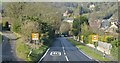
Sussex Gardens, East Dean
A fairly recent estate built on what looks like an old sewage works and the extensive grounds of a former house. A footpath once ran through here to Downs View Lane but now only goes as far as this road.
Image: © Simon Carey
Taken: 14 Dec 2013
0.02 miles
2
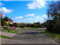
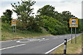
Elven Lane, Eastdean
Part of a housing estate to the north of the main A259. This view looks north eastwards with Pea Down rising in the background.
Image: © Simon Carey
Taken: 5 Apr 2006
0.05 miles
3
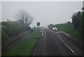
East Dean
The area north of the A259 is known as the Downlands Estate that was initially developed from the late 1920s onwards though largely completed after the Second World War. Many of the roads remain private regarding vehicular access though can be used by pedestrians.
Image: © Simon Carey
Taken: 14 Dec 2013
0.06 miles
8
Cophall Lane, East Dean
A private dead end lane leading to a number of houses along the lower slopes of Eastdean Down on the eastern side of the village. The house to the left is Old Barn whilst to the right is Bremlyngs. The latter was built in the 1970s on the site of Cophall a building marked on East Dean's 1844 tithe map but was in ruins by the 1875 and 1899 OS maps before disappearing altogether. Bremlyng is the old name of an area of downland to the east now part of Bramble Bottom. The former was originally an outbuilding of Cop Hall and has now been converted into a residence.
Image: © Simon Carey
Taken: 26 Dec 2013
0.07 miles
9
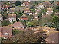
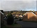
East Dean roofscape
Houses on Downs View Lane and Elven Lane.
Image: © Oast House Archive
Taken: 3 Oct 2011
0.07 miles
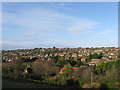
10
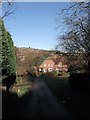
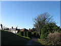
Downs View Close, East Dean
A postwar cul de sac heading north of Image Beyond is the Downlands Estate of East Dean clinging to the southern slopes of Summer Down.
Image: © Simon Carey
Taken: 26 Dec 2013
0.07 miles