IMAGES TAKEN NEAR TO
The Ridgeway, EASTBOURNE, BN20 0EU
Introduction
This page details the photographs taken nearby to The Ridgeway, BN20 0EU by members of the Geograph project.
The Geograph project started in 2005 with the aim of publishing, organising and preserving representative images for every square kilometre of Great Britain, Ireland and the Isle of Man.

There are currently over 7.5m images from over14,400 individuals and you can help contribute to the project by visiting https://www.geograph.org.uk
Image Map
Images are licensed for reuse under creativecommons.org/licenses/by-sa/2.0
Notes
- Clicking on the map will re-center to the selected point.
- The higher the marker number, the further away the image location is from the centre of the postcode.
Image Listing (48 Images Found)
Images are licensed for reuse under creativecommons.org/licenses/by-sa/2.0
Image
Details
Distance
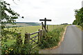
1
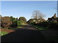
The Ridgeway, Friston
Part of a private estate that was developed from the late 1920s onwards though was not completed until after the Second World War. The residential road runs from Windmill Lane in the south and joins with Warren Lane at the junction with The Brow. All of the area in view was once part of a field called Little Pasture according to Friston's 1848 tithe map.
Image: © Simon Carey
Taken: 16 Nov 2013
0.05 miles
2
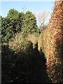
Footpath to Old Willingdon Road
Linking that road with The Ridgeway and flanked by high hedges of the properties on that road.
Image: © Simon Carey
Taken: 16 Nov 2013
0.05 miles
3
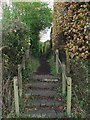
Footpath to The Ridgeway
Viewed from its entrance on Old Willingdon Road.
Image: © Simon Carey
Taken: 23 Nov 2013
0.07 miles
4
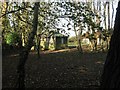
Little Pasture
A small patch of land used to pasture a couple of sheep located on what was once a much larger field called Little Pasture according to Friston's 1848 tithe map. The field's old western boundary was Old Willingdon Road, its eastern one, the old parish boundary with Eastdean, and covered the northern end of what is now The Ridgeway and Warren Lane and the southern part of The Brow.
Image: © Simon Carey
Taken: 16 Nov 2013
0.08 miles
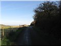
6
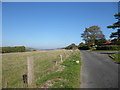
Old Willingdon Road
Old Willingdon Road eventually becomes a bridleway and heads up on to the South Downs at Willingdon Hill. There are some very exclusive houses on the right along here.
Image: © Marathon
Taken: 21 Oct 2018
0.10 miles
7
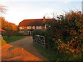
Appledown, Old Willington Road, Friston
A large house built on the old Friston-Willingdon road during the 1930s catching the last sunlight of the day.
Image: © Simon Carey
Taken: 23 Nov 2013
0.10 miles
9

Friston Field, Old Willingdon Road, Friston
A large house built in the 1930s and named after the field it was built in as noted in Friston's 1848 tithe map. The house lies to the immediate north of Image
Image: © Simon Carey
Taken: 23 Nov 2013
0.11 miles
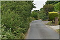
10
Old Willingdon Road, Friston
The old lane that once linked Friston to Willingdon that ran across the Downs via Willingdon Hill before descending to its destination via Butts Lane. The current highway ends at Field House Farm before becoming a bridleway.
Image: © Simon Carey
Taken: 16 Nov 2013
0.11 miles