IMAGES TAKEN NEAR TO
Standean, BRIGHTON, BN1 8ZB
Introduction
This page details the photographs taken nearby to Standean, BN1 8ZB by members of the Geograph project.
The Geograph project started in 2005 with the aim of publishing, organising and preserving representative images for every square kilometre of Great Britain, Ireland and the Isle of Man.

There are currently over 7.5m images from over14,400 individuals and you can help contribute to the project by visiting https://www.geograph.org.uk
Image Map
Images are licensed for reuse under creativecommons.org/licenses/by-sa/2.0
Notes
- Clicking on the map will re-center to the selected point.
- The higher the marker number, the further away the image location is from the centre of the postcode.
Image Listing (12 Images Found)
Images are licensed for reuse under creativecommons.org/licenses/by-sa/2.0
Image
Details
Distance
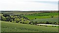
1
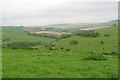
Looking towards Lower Standean
Taken from the minor road leading north up into Lower Standean. Most of the community is hidden behind the slopes to the right of the red roofed house.
Image: © Peter Whitcomb
Taken: 14 May 2006
0.01 miles
2
Mid-down House
This was taken from the bridleway which is not apparent on the ground (see Image]).
Image: © Shazz
Taken: 13 Mar 2017
0.01 miles
3

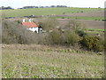
Mid-Down House
Built between the wars and currently owned by Standean Farm who run it as a bed and breakfast.
Image: © Simon Carey
Taken: 25 Apr 2020
0.01 miles
4
Mid-down House
At the north end of Donkey Bottom.
Image: © Dave Spicer
Taken: 20 Feb 2011
0.04 miles
5
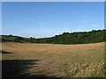
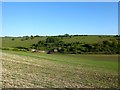
Wonderhill Plantation
The name of the wood at the end of the field. On the 1843 tithe map this field is marked as sheep down. Tegdown Hill is in the distance on the left.
Image: © Simon Carey
Taken: 23 Aug 2009
0.18 miles
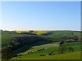
6
Donkey Bottom
With Tegdown Hill beyond.
Image: © Simon Carey
Taken: 25 Apr 2020
0.19 miles
7
Eight Acres/New Barn Field
The name of the field according to Ditchling's 1839 tithe map viewed from Tegdown Hill. New Barn Field is on the right of the lane leading to Standean whilst Eight Acres is to the left overlooked by Wonderhill Plantation
Image: © Simon Carey
Taken: 16 Apr 2014
0.21 miles
8
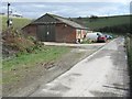
Ditchling, shed
The road is a bridleway leading to Lower Standean farm
Image: © Peter Cox
Taken: 17 Mar 2008
0.22 miles
9
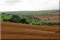
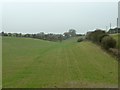
Ewe Bottom
The road to Lower Standean Farm winds its way up the bottom, the track to Middown House branches off this and curves round the spur on the right.
Image: © Robin Webster
Taken: 13 Sep 2010
0.22 miles
10
View WSW from a point south of New Barn
The track on the left heads up to Lower Standean - which lies to the right of the photo.
Image: © Ian Hawfinch
Taken: 15 Jun 2020
0.22 miles