IMAGES TAKEN NEAR TO
Carden Crescent, BRIGHTON, BN1 8TQ
Introduction
This page details the photographs taken nearby to Carden Crescent, BN1 8TQ by members of the Geograph project.
The Geograph project started in 2005 with the aim of publishing, organising and preserving representative images for every square kilometre of Great Britain, Ireland and the Isle of Man.

There are currently over 7.5m images from over14,400 individuals and you can help contribute to the project by visiting https://www.geograph.org.uk
Image Map
Images are licensed for reuse under creativecommons.org/licenses/by-sa/2.0
Notes
- Clicking on the map will re-center to the selected point.
- The higher the marker number, the further away the image location is from the centre of the postcode.
Image Listing (11 Images Found)
Images are licensed for reuse under creativecommons.org/licenses/by-sa/2.0
Image
Details
Distance
1

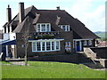
View down Portfield Avenue
Many residential areas of Brighton have the benefit of extensive views, even if it is only of other residential areas.
Image: © Robin Webster
Taken: 30 Apr 2010
0.07 miles
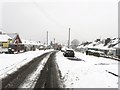
2
Portfield Avenue, Patcham
A residential road built in the 1930s that links Ladies Mile Road with Carden Crescent.
Image: © Simon Carey
Taken: 20 Jan 2013
0.13 miles
3
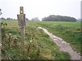
Footpath over Golf Course
The start of the footpath to Hollingbury Hill Fort. The sign warns walkers to be aware of golfers.
Image: © Bob Embleton
Taken: 11 Sep 2005
0.15 miles
4
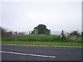
Reservoir ? or ROC Monitoring Post
This very small "water" facility is close to much larger reservoirs. Its size, shape and location reminds me more of a Royal Observer Corps Monitoring Post to observe nuclear bomb damage. It doesn't appear on the data bases.
Image: © Bob Embleton
Taken: 11 Sep 2005
0.15 miles
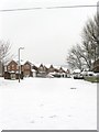
5
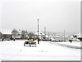
Ladies Mile Road, Patcham
Originally an old drove road that linked Patcham village with Ditchling Road at Old Boat Corner. During the 19th century it picked up its current name when it became part of a circular horse riding route that also took in London Road, Ditchling Road and Surrenden Road. The road became residential during the 1930s when a number of the bungalows in view were built. A gritting lorry can be seen further down the road.
Image: © Simon Carey
Taken: 20 Jan 2013
0.19 miles
6

Petworth Road, Hollingbury
Small estate of Carden Avenue built in the late 1930s.
Image: © Simon Carey
Taken: 20 Jan 2013
0.20 miles
7
Windmill View, Patcham
A recently constructed small estate built on the site of Patcham Fawcett secondary school for boys which occupied this spot from 1965 until it amalgamated with the nearby girl school in 1989 and formed Patcham High School.
Image: © Simon Carey
Taken: 20 Jan 2013
0.20 miles
8

Carden Avenue, Hollingbury
The main thoroughfare for the estates that were built to the east of Patcham between the 1930s and 1950s beginning at London Road, the A23 in the west and ending at Ditchling Road at Old Boat corner in the east. This view looks down the hill towards Carden Primary School.
Image: © Simon Carey
Taken: 20 Jan 2013
0.21 miles
9
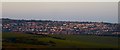
Hollingbury, Brighton
The outer suburb viewed from Holt Hill is catching the last of the evening sun.
Image: © Simon Carey
Taken: 25 Apr 2020
0.21 miles