IMAGES TAKEN NEAR TO
Braypool Lane, BRIGHTON, BN1 8PP
Introduction
This page details the photographs taken nearby to Braypool Lane, BN1 8PP by members of the Geograph project.
The Geograph project started in 2005 with the aim of publishing, organising and preserving representative images for every square kilometre of Great Britain, Ireland and the Isle of Man.

There are currently over 7.5m images from over14,400 individuals and you can help contribute to the project by visiting https://www.geograph.org.uk
Image Map
Images are licensed for reuse under creativecommons.org/licenses/by-sa/2.0
Notes
- Clicking on the map will re-center to the selected point.
- The higher the marker number, the further away the image location is from the centre of the postcode.
Image Listing (27 Images Found)
Images are licensed for reuse under creativecommons.org/licenses/by-sa/2.0
Image
Details
Distance
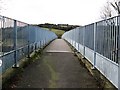
1
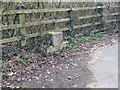
Unused mounting block by Brownie's Bridge
Although a bridleway I think most horse riders would be wary of leading a horse over seven lanes of traffic and a main line railway.
Image: © Dave Spicer
Taken: 6 Mar 2010
0.00 miles
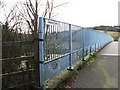
3
Sussex Border Path approaching the A23 crossing
To the right of the fence is a RSPCA shelter.
Image: © Dave Spicer
Taken: 6 Mar 2010
0.01 miles

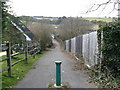
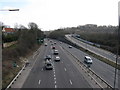
7
Brownie's Bridge over the A23
Sweet Hill in the centre
Image: © Dave Spicer
Taken: 6 Mar 2010
0.08 miles
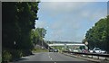
8
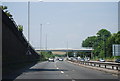
A23 approaching Brighton
The two lanes on the left connect to the A27 east and west bound
Image: © Dave Spicer
Taken: 6 Mar 2010
0.08 miles
9
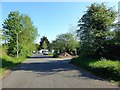
Braypool Lane, Patcham, Brighton
The road was built in early 1990s to provide access for about 20 houses, an RSPCA shelter and Braypool Sports Ground that originally fronted onto the A23.
Image: © Simon Carey
Taken: 25 Apr 2020
0.08 miles
10
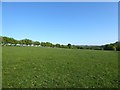
Lower Court Laine South
The name of the field according to Patcham's 1842 tithe map. This is the remaining eastern portion with much of the rest lost to housing and the A23. Much of the Brighton Council area north of Patcham became open access land about five years ago.
Image: © Simon Carey
Taken: 25 Apr 2020
0.08 miles