IMAGES TAKEN NEAR TO
Wepham, ARUNDEL, BN18 9RQ
Introduction
This page details the photographs taken nearby to BN18 9RQ by members of the Geograph project.
The Geograph project started in 2005 with the aim of publishing, organising and preserving representative images for every square kilometre of Great Britain, Ireland and the Isle of Man.

There are currently over 7.5m images from over14,400 individuals and you can help contribute to the project by visiting https://www.geograph.org.uk
Image Map
Images are licensed for reuse under creativecommons.org/licenses/by-sa/2.0
Notes
- Clicking on the map will re-center to the selected point.
- The higher the marker number, the further away the image location is from the centre of the postcode.
Image Listing (100 Images Found)
Images are licensed for reuse under creativecommons.org/licenses/by-sa/2.0
Image
Details
Distance
1
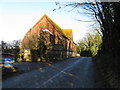
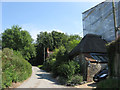
Wepham Farm Cottages, The Splash, Wepham
Lying at a right angle to the small lane they are located on. They don't appear on any OS maps until 1973 so were possibly built in the 1960s though they look a decade or two older in style.
Image: © Simon Carey
Taken: 20 Aug 2013
0.01 miles
2
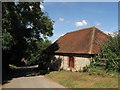
Wepham Farm Stables, The Splash, Wepham
Originally a cattle shed constructed in 1841 the former buildings of Wepham Farm have now been converted into holiday homes
Image: © Simon Carey
Taken: 20 Aug 2013
0.02 miles
4
104, The Splash, Wepham
A 17th century cottage which appears to be undergoing renovation to its thatched roof.
Image: © Simon Carey
Taken: 1 Aug 2013
0.02 miles
5
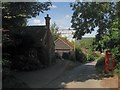
Backwoods, The Splash, Wepham
A flint cottage on the lane to Burpham with the old village phone box opposite, but don't expect to find a phone inside.
Image: © Simon Carey
Taken: 20 Aug 2013
0.02 miles
6
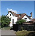
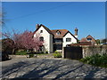
Wepham House, The Splash, Wepham
The former farmhouse for Wepham Farm until that was superseded by Home Farm out on Perry Hill.
Image: © Simon Carey
Taken: 20 Aug 2013
0.03 miles
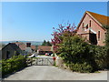
8
102-103 The Splash, Wepham
Two flint cottages on the narrow lane that links Wepham to Burpham. The lane is named after the former ford that existed until the 1970s at the bottom of the slope. The dwellings are numbered according to the estate as opposed to the road they are one.
Image: © Simon Carey
Taken: 1 Aug 2013
0.04 miles
9
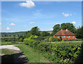
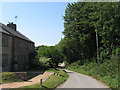
Wepham village
The road below leads to Wepham then onto Burpham.
Image: © Dave Spicer
Taken: 18 Jan 2009
0.04 miles