IMAGES TAKEN NEAR TO
Wepham, ARUNDEL, BN18 9RE
Introduction
This page details the photographs taken nearby to BN18 9RE by members of the Geograph project.
The Geograph project started in 2005 with the aim of publishing, organising and preserving representative images for every square kilometre of Great Britain, Ireland and the Isle of Man.

There are currently over 7.5m images from over14,400 individuals and you can help contribute to the project by visiting https://www.geograph.org.uk
Image Map
Images are licensed for reuse under creativecommons.org/licenses/by-sa/2.0
Notes
- Clicking on the map will re-center to the selected point.
- The higher the marker number, the further away the image location is from the centre of the postcode.
Image Listing (136 Images Found)
Images are licensed for reuse under creativecommons.org/licenses/by-sa/2.0
Image
Details
Distance
1
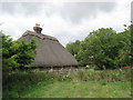
Court Leet Cottage, Wepham
The cottage dates from the 15th century and was once the meeting place of the local court leet, hence its name.
Image: © Simon Carey
Taken: 14 Aug 2013
0.02 miles
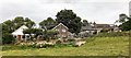
5
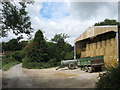
Modern Barn, The Splash, Wepham
The roof of Image can be seen in the distance to the left.
Image: © Simon Carey
Taken: 14 Aug 2013
0.02 miles
6
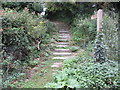
Steps and fingerpost
Public footpath 2231 to Burpham.
Image: © Peter Holmes
Taken: 17 Aug 2013
0.03 miles
7
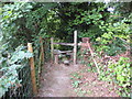
Stile near Wepham Green
Public footpath 2231.
Image: © Peter Holmes
Taken: 17 Aug 2013
0.03 miles
8
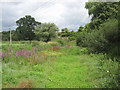
Site of Shettle Pond
Named as such on Burpham's 1840 tithe map. Originally formed from the waters of Boundary Brook as a mill pond for a water mill that was recorded here from the Domesday Book to the at least the 17th century. The pond survived until at least the early 1970s when the southern end seems to have been filled in when the nearby former ford was culverted. A small part remains a little to the north before the rise in land, see Image
Image: © Simon Carey
Taken: 14 Aug 2013
0.05 miles
9
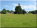
Wepham Green
Former green in the hamlet of Wepham.
Image: © Simon Carey
Taken: 1 Aug 2013
0.05 miles
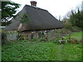
10
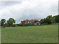
Council Cottages, Wepham
Two sets of three cottages built in different styles that lie at a right angle to the lane. My guess is the set on the left were built before the Second World War whilst that on the right were built after.
Image: © Simon Carey
Taken: 14 Aug 2013
0.06 miles