IMAGES TAKEN NEAR TO
Warningcamp, ARUNDEL, BN18 9QY
Introduction
This page details the photographs taken nearby to BN18 9QY by members of the Geograph project.
The Geograph project started in 2005 with the aim of publishing, organising and preserving representative images for every square kilometre of Great Britain, Ireland and the Isle of Man.

There are currently over 7.5m images from over14,400 individuals and you can help contribute to the project by visiting https://www.geograph.org.uk
Image Map
Images are licensed for reuse under creativecommons.org/licenses/by-sa/2.0
Notes
- Clicking on the map will re-center to the selected point.
- The higher the marker number, the further away the image location is from the centre of the postcode.
Image Listing (56 Images Found)
Images are licensed for reuse under creativecommons.org/licenses/by-sa/2.0
Image
Details
Distance
1
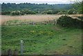
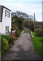
Lower Common (1)
The name of the field according to Warningcamp's 1840 tithe map which was once one of the large open fields that surrounded the hamlet and survived from the medieval period until enclosure in 1812. During the 1850s the land was acquired by a local building society who began laying out roads and some building began including The Woodleighs and Sefton House, however, no large scale building occurred and eventually the land was partially occupied by nurseries, one of whom, Yeomans, still operate here. Sefton Place Cottages and Bethany are the two buildings which can be seen beyond the glasshouses.
Image: © Simon Carey
Taken: 19 Aug 2013
0.05 miles
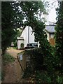
3
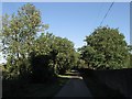
Wharf Lane
The name of the narrow lane that heads west towards the river. Originally an extension of the main village street it was believed it once headed towards a ford. Later on it provided access to Image until that fell into disuse. From 1855 it has been the entry and exit point for the houses and businesses built from 1855 onwards.
Image: © Simon Carey
Taken: 19 Aug 2013
0.06 miles
4
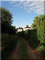
Lane to Warningcamp
Small lane heading back from the railway line towards the hamlet of Warningcamp. The lane does not cross the line.
Image: © Simon Carey
Taken: 30 Dec 2007
0.07 miles
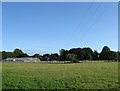
5
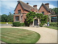
Warningcamp House
Victorian house first built in 1820. Set in 11 acres of garden and fields
http://www.wherecanwego.com/Search/ViewEvent.aspx?e=238705&h=West+Sussex+Warningcamp+House+-+Open+Garden
Image: © Paul Gillett
Taken: 5 Jul 2009
0.07 miles
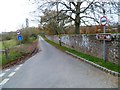
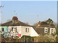
6
Crossing Cottage/The Gate House, Wharf Lane, Warningcamp
The Gate House on the right was built in the 1860s as a pair of cottages operating the railway crossing on Wharf Lane. At some point in the not too distant past the cottages were joined together and another, Crossing Cottage, was added on the left. The track is the old highway connecting what was Warningcamp Wharf with Wepham and Burpham. It is now a public footpath.
Image: © Simon Carey
Taken: 20 Aug 2013
0.08 miles
7
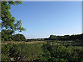
First Brook
The name of the field according to Warningcamp's 1840 tithe map. This is the western remnant of the small field that was split in two by the construction of the Arun valley railway in the 1860s.
Image: © Simon Carey
Taken: 19 Aug 2013
0.08 miles
8
Lodge Cottage/Lane End, Warningcamp
A pair of cottages built around the 1860s on what was former common land. There were plans to build a residential area between the railway and what is now Burpham Road and a brickworks was set up on the flood plain in anticipation but nothing came of it except a few houses.
Image: © Simon Carey
Taken: 20 Aug 2013
0.10 miles
9
Foot crossing
A unguarded foot crossing (i.e. no locks or warning lights when a train is coming) where the footpath from Warningcamp to Arundel crosses the railway.
Image: © Stephen Craven
Taken: 5 Apr 2007
0.10 miles