IMAGES TAKEN NEAR TO
Rackham Road, ARUNDEL, BN18 9NT
Introduction
This page details the photographs taken nearby to Rackham Road, BN18 9NT by members of the Geograph project.
The Geograph project started in 2005 with the aim of publishing, organising and preserving representative images for every square kilometre of Great Britain, Ireland and the Isle of Man.

There are currently over 7.5m images from over14,400 individuals and you can help contribute to the project by visiting https://www.geograph.org.uk
Image Map
Images are licensed for reuse under creativecommons.org/licenses/by-sa/2.0
Notes
- Clicking on the map will re-center to the selected point.
- The higher the marker number, the further away the image location is from the centre of the postcode.
Image Listing (11 Images Found)
Images are licensed for reuse under creativecommons.org/licenses/by-sa/2.0
Image
Details
Distance
1
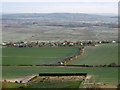
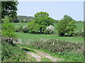
Cross Gates
Small hamlet between Amberley and Rackham viewed from Amberley Mount. The field boundary running north-south marks the boundary of the parishes of Amberley and Parham and may account for the name of the hamlet perhaps being the gated entrance to one or other of the above named as the lane is the old main road from Storrington which was superseded by the B2139 in the late 18th/early 19th century. Beyond Cross Gates is Amberley Wild Brooks once an area of marshland now mostly recovered for agriculture.
Image: © Simon Carey
Taken: 5 Apr 2009
0.10 miles
2

Converging lines by the footpath to Amberley
From Rackham Mill.
I had covered a few miles, on a round trip from Pulborough, yet this was the first and only arable field I crossed.
Image: © Chris
Taken: 14 Jun 2014
0.10 miles
3
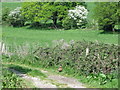
Public footpath at Rackham, West Sussex
Note the cock pheasant in the middle lower part of the picture.
Image: © nick macneill
Taken: 25 Apr 2011
0.13 miles
4
View across the water meadows from Cross Gate
Image: © Jeff Tomlinson
Taken: 10 Sep 2017
0.15 miles
5
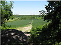
Across the Field
As a rainbow fades from the sky, the path leads, via the woods, to Rackham Mill. Oh to have been here a few minutes earlier!
Image: © Peter Trimming
Taken: 13 Sep 2011
0.16 miles
6
Public footpath at Rackham, West Sussex
Image: © nick macneill
Taken: 25 Apr 2011
0.18 miles
7

Rackham Road into Amberley, with South Downs behind
Image: © Chris
Taken: 14 Jun 2014
0.18 miles
8
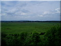
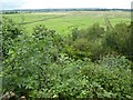
Part of Amberley Wild Brooks
Grassland dissected by numerous ditches, mostly dug in the 1800s to assist drainage.
Image: © Peter Holmes
Taken: 6 Jun 2010
0.18 miles
9
Footpath from Rackham Street to Rackham Mill
Image: © Dave Spicer
Taken: 30 May 2009
0.23 miles
10
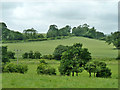
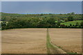
View from Rackham Road towards Amberley
Rackham Road bends round to climb the rise along the far hedgerow on the other side of the dip.
Image: © Robin Webster
Taken: 21 Jun 2011
0.24 miles