IMAGES TAKEN NEAR TO
Hog Lane, ARUNDEL, BN18 9NH
Introduction
This page details the photographs taken nearby to Hog Lane, BN18 9NH by members of the Geograph project.
The Geograph project started in 2005 with the aim of publishing, organising and preserving representative images for every square kilometre of Great Britain, Ireland and the Isle of Man.

There are currently over 7.5m images from over14,400 individuals and you can help contribute to the project by visiting https://www.geograph.org.uk
Image Map
Images are licensed for reuse under creativecommons.org/licenses/by-sa/2.0
Notes
- Clicking on the map will re-center to the selected point.
- The higher the marker number, the further away the image location is from the centre of the postcode.
Image Listing (314 Images Found)
Images are licensed for reuse under creativecommons.org/licenses/by-sa/2.0
Image
Details
Distance
1
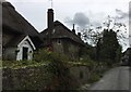
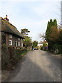
Thatched Cottages at Amberley
There are a number of Thatched Cottages in the picturesque village of Amberley.
Image: © Chris Thomas-Atkin
Taken: 3 Sep 2017
0.01 miles
4
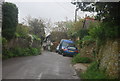
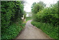
Hog Lane
Connecting the road junction at the Black Horse with Church Street.
Image: © Simon Carey
Taken: 5 Apr 2009
0.01 miles
6
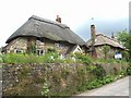
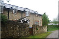
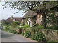
Old Thatched Cottages
These cottages are on Hog Lane, and are typical of many homes in Amberley.
Image: © mike smith
Taken: 26 Jun 2007
0.02 miles
9
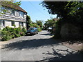
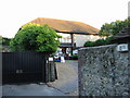
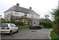
Houses in Hog Lane, Amberley
The houses in Amberley are generally attractive throughout the village. This view is in Hog Lane, parallel to the better-known Church Street.
Image: © Marathon
Taken: 26 Apr 2011
0.03 miles