IMAGES TAKEN NEAR TO
Houghton Bridge, ARUNDEL, BN18 9LP
Introduction
This page details the photographs taken nearby to Houghton Bridge, BN18 9LP by members of the Geograph project.
The Geograph project started in 2005 with the aim of publishing, organising and preserving representative images for every square kilometre of Great Britain, Ireland and the Isle of Man.

There are currently over 7.5m images from over14,400 individuals and you can help contribute to the project by visiting https://www.geograph.org.uk
Image Map
Images are licensed for reuse under creativecommons.org/licenses/by-sa/2.0
Notes
- Clicking on the map will re-center to the selected point.
- The higher the marker number, the further away the image location is from the centre of the postcode.
Image Listing (330 Images Found)
Images are licensed for reuse under creativecommons.org/licenses/by-sa/2.0
Image
Details
Distance
1
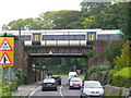
Amberley Station Railway Bridge
The station itself is just right of photograph. A Littlehampton train is sitting above the road. Amberley village itself is about 1-2 miles north of the station.
Image: © Colin Smith
Taken: 1 Sep 2007
0.01 miles
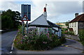
2
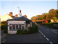
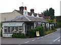
The Turnpike
Former toll cottage on the modern B2139 at Houghton Bridge. The turnpike itself was opened in 1813 taking over the old route from Whiteways Lodge via the 14th century Houghton Bridge to a point south of Amberley. From here a new road was constructed to Storrington that by-passed the grounds of Parham House to the south which enabled the owners to close the old road that ran next to the house to the north. The current B2139 follows the entire route today. Beyond the cottage is the railway bridge next to Amberley station.
Image: © Simon Carey
Taken: 24 Oct 2008
0.01 miles
3
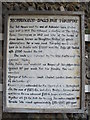
Storrington Balls Hut Turnpike Sign
Old wooden sign advertising the tolls which were collected when they were payable by travellers crossing Houghton Bridge. The wording covers such unusual vehicles as berlins, chariots and landaus.
Image: © Colin Smith
Taken: 1 Sep 2007
0.02 miles
4
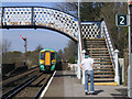
Amberley Station
The station is actually closer to the villages of Houghton and North Stoke than to Amberley itself. The line from Horsham to Chichester must be one of the few in the South-East still to have the old semaphore signals.
Image: © Stephen Craven
Taken: 6 Apr 2007
0.02 miles
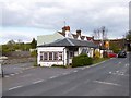
5
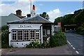
The Turnpike
Old turnpike cottage on the eastern end of Houghton Bridge where tolls would have been collected from passing travellers. Today it still takes money from travellers!
Image: © Colin Smith
Taken: 1 Sep 2007
0.02 miles
6
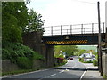
Railway Bridge at Amberley
Just north of the station.
Image: © Peter Trimming
Taken: 12 May 2009
0.02 miles
7
Old Toll House by the B2139, Houghton Bridge, Amberley
Houghton Bridge toll house by the B2139 (was A29), in parish of Amberley (Horsham District), Turnpike, Houghton Bridge, BN18 9LP.
Grade II listed.
List Entry Number: 1027477 https://historicengland.org.uk/listing/the-list/list-entry/1027477
Surveyed
Milestone Society National ID: WS.AMB
Image: © Milestone Society
Taken: Unknown
0.02 miles
8
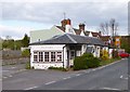
The Turnpike, Amberley, Sussex
The Turnpike is a former toll-house, dating from the early 19th century. Located at the eastern end of Houghton Bridge. In the distance, the railway bridge carrying the Arun Valley Line can be seen.
Image: © Peter Trimming
Taken: 13 Sep 2011
0.02 miles
9
The Turnpike, Amberley, Sussex
The Turnpike is a former toll-house, dating from the early 19th century. Located at the eastern end of Houghton Bridge, Amberley. In the distance, Bury Hill can be seen.
Image: © Peter Trimming
Taken: 13 Sep 2011
0.02 miles
10
Amberley, The Turnpike
Former tollhouse at Houghton Bridge, built in 1813, probably with later additions at each end; listed by English Heritage, http://www.imagesofengland.org.uk/details/default.aspx?id=298265
Image: © Mike Faherty
Taken: 15 Apr 2012
0.02 miles