IMAGES TAKEN NEAR TO
Malthouse Close, ARUNDEL, BN18 9JF
Introduction
This page details the photographs taken nearby to Malthouse Close, BN18 9JF by members of the Geograph project.
The Geograph project started in 2005 with the aim of publishing, organising and preserving representative images for every square kilometre of Great Britain, Ireland and the Isle of Man.

There are currently over 7.5m images from over14,400 individuals and you can help contribute to the project by visiting https://www.geograph.org.uk
Image Map (Loading...)


Getting Data...Please wait
Leaflet Map data © OpenStreetMap
Images are licensed for reuse under creativecommons.org/licenses/by-sa/2.0
Notes
- Clicking on the map will re-center to the selected point.
- The higher the marker number, the further away the image location is from the centre of the postcode.
Image Listing (84 Images Found)
Images are licensed for reuse under creativecommons.org/licenses/by-sa/2.0
Image
Details
Distance
1
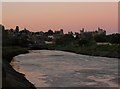
River Arun
Viewed about five minutes after sunset with the sky pink over the town of Arundel and reflecting into the river. The A27 by-pass bridge is in the foreground with an old open deck bus crossing it. It had been parked in the car park of the Black Horse in Binsted where I'd tried to get a picture but the only view was looking straight at the sun so I gave up on the idea. Only noticed it crossing the bridge after downloading it onto my PC.
Image: © Simon Carey
Taken: 10 Oct 2010
0.04 miles
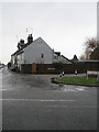
2
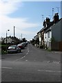
Fitzalan Road
Originally laid out in the 1930s it is one of the few developments south of the river. The road was split in two by the building of the by-pass in 1973.
Image: © Simon Carey
Taken: 13 Apr 2009
0.07 miles
3
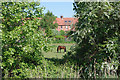
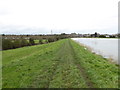
Horse in field
A low-lying field between the River Arun and Ford Road, viewed from the river wall.
Image: © Robin Webster
Taken: 24 May 2010
0.08 miles
4
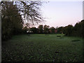
Longmores Field
The name of the field according to the 1840 tithe map that lies between the river embankment and Ford Road. Originally part of Tortington parish but transferred to Arundel in 1905 and has survived the building development that has happened elsewhere east of the river and south of the A27. Taken seven minutes before sunrise with a touch of frost visible on the ground.
Image: © Simon Carey
Taken: 24 Oct 2010
0.08 miles
5
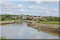
Looking up the River Arun towards Arundel
The large building on the skyline is the cathedral in the next grid square to the north.
Image: © Shazz
Taken: 28 Nov 2015
0.09 miles
6
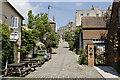
King's Arms Hill. Arundel
Looking north from Tarrant Street.
Image: © David Brogan
Taken: 23 May 2007
0.09 miles
7
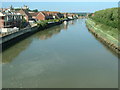
River Arun
Looking NE from the relief road bridge
Image: © Chris Shaw
Taken: Unknown
0.09 miles
8
River Arun, Arundel
Approaching Arundel from the south with the Cathedral in front and Arundel Castle off to the right.
Image: © Chris Richardson
Taken: 3 May 2009
0.09 miles
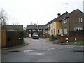
9
Approaching the junction of Fitzalan Road and Dalton's Place
Image: © Basher Eyre
Taken: 30 Dec 2009
0.10 miles
10
Looking from Fitzalan Road into Dalton's Place
Image: © Basher Eyre
Taken: 30 Dec 2009
0.10 miles