IMAGES TAKEN NEAR TO
Arun Terrace, Ford Road, ARUNDEL, BN18 9EG
Introduction
This page details the photographs taken nearby to Arun Terrace, Ford Road, BN18 9EG by members of the Geograph project.
The Geograph project started in 2005 with the aim of publishing, organising and preserving representative images for every square kilometre of Great Britain, Ireland and the Isle of Man.

There are currently over 7.5m images from over14,400 individuals and you can help contribute to the project by visiting https://www.geograph.org.uk
Image Map
Images are licensed for reuse under creativecommons.org/licenses/by-sa/2.0
Notes
- Clicking on the map will re-center to the selected point.
- The higher the marker number, the further away the image location is from the centre of the postcode.
Image Listing (45 Images Found)
Images are licensed for reuse under creativecommons.org/licenses/by-sa/2.0
Image
Details
Distance
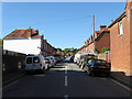
1
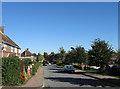
Priory Road
Looking down towards the junction with Ford Road. Now a residential street in Arundel it had once been an access route from the town to Tortington Priory which was blocked up sometime in the 17th century.
Image: © Simon Carey
Taken: 10 Oct 2010
0.04 miles
2
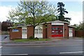
Arundel fire stationfire s
Arundel fire station, 49 Ford Road, Arundel, West Sussex
Image: © Kevin Hale
Taken: 28 Apr 2009
0.04 miles
4
Looking up the River Arun towards Arundel
The large building on the skyline is the cathedral in the next grid square to the north.
Image: © Shazz
Taken: 28 Nov 2015
0.10 miles
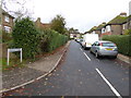
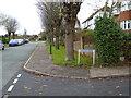
5
Kirdford Road
Residential road linking Ford Road with Torton Hill Road. The built up area to the south west of old area originally lay in the parish of Tortington until the end of the 19th century when it was added to Arundel specifically to develop. However, development was slow with only Wood View, a cul-de-sac off this road, built before the 20th century and only the bottom end of this road built before the First World War.
Image: © Simon Carey
Taken: 10 Oct 2010
0.10 miles
6
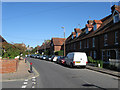
California Mews, Ford Road
A late 19th century row of terrace houses alongside the minor road to Ford.
Image: © Simon Carey
Taken: 10 Oct 2010
0.10 miles
7
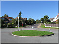
Looking west to the roundabout from the southern end of Howard Road
Image: © Shazz
Taken: 28 Nov 2015
0.11 miles
8
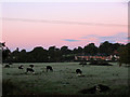
Burberry's Field
The name of the field according to the 1840 tithe map. Once part of Tortington parish but transferred to Arundel in 1905 but saved from development due to it being part of the Arun flood plain. Taken a minute after sunrise with the frost evident on the ground.
Image: © Simon Carey
Taken: 24 Oct 2010
0.12 miles
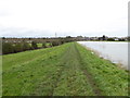
9
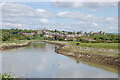
River Arun, Arundel
Approaching Arundel from the south with the Cathedral in front and Arundel Castle off to the right.
Image: © Chris Richardson
Taken: 3 May 2009
0.12 miles
10
Bernard Road
Viewed from the junction with Priory Road. The area was developed after the Second World War.
Image: © Simon Carey
Taken: 10 Oct 2010
0.13 miles