IMAGES TAKEN NEAR TO
Meadowsweet View, ARUNDEL, BN18 0XN
Introduction
This page details the photographs taken nearby to Meadowsweet View, BN18 0XN by members of the Geograph project.
The Geograph project started in 2005 with the aim of publishing, organising and preserving representative images for every square kilometre of Great Britain, Ireland and the Isle of Man.

There are currently over 7.5m images from over14,400 individuals and you can help contribute to the project by visiting https://www.geograph.org.uk
Image Map
Images are licensed for reuse under creativecommons.org/licenses/by-sa/2.0
Notes
- Clicking on the map will re-center to the selected point.
- The higher the marker number, the further away the image location is from the centre of the postcode.
Image Listing (36 Images Found)
Images are licensed for reuse under creativecommons.org/licenses/by-sa/2.0
Image
Details
Distance
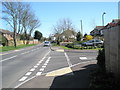
1
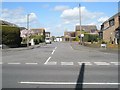
Looking from Burndell Road into Goodhew Close
Image: © Basher Eyre
Taken: 8 Apr 2009
0.05 miles
2
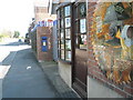
Unusual postbox in Burndell Road
It is in fact just for private mail for the tool shop.
Image: © Basher Eyre
Taken: 8 Apr 2009
0.05 miles
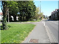
4
Looking from Burndell Road into Downview Road
Image: © Basher Eyre
Taken: 8 Apr 2009
0.09 miles
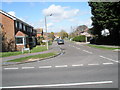
5
Junction of Burndell Road and Fellows Gardens
Image: © Basher Eyre
Taken: 8 Apr 2009
0.09 miles
7
The old canal bridge, north of Burndell Road, Yapton
The old bridge (pictured) is scheduled to be demolished by the developers, when the new estate of some 170 houses is built in and around these fields where the bridge is situated. Quite when the building will commence nobody knows but planning permission has been granted so building with almost certainly take place. Unless the bridge is listed by the local authority, we shall lose it. The canal was originally constructed to carry (amongst other things) munitions to and from London/Portsmouth during the Napoleonic wars. It was never a viably operating system.
Image: © Peter H Jones
Taken: 23 May 2012
0.09 miles
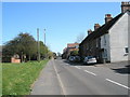
8
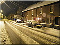
Holkham Cottages and beyond looking east on Burndell Road, Yapton
The picture was taken late at night in January this year as the snow fell silently, steadily and softly. The light is provided only by the sodium street lights and the reflection of the snow. Beyond Holkham Cottages is the Leeside Tool Shop and then the social houses and flats of Ryebank Walk occupy the former site of James Garage. Beyond these buildings are the car park of the Yapton Metal Company and then Wayside one of the oldest houses in the village and undoubtedly the oldest in this square.
Image: © Peter H Jones
Taken: 5 Jan 2010
0.10 miles
9
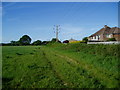
Public footpath 167
Showing rear of houses in Park Drive.
Image: © Peter Holmes
Taken: 22 May 2010
0.10 miles
10
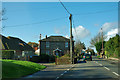
House at the parish boundary
Once the first house in Yapton, this flint and brick house is set at an odd angle to the road for no obvious reason.
Image: © Robin Webster
Taken: 26 Jan 2012
0.10 miles