IMAGES TAKEN NEAR TO
Copse Lane, ARUNDEL, BN18 0QJ
Introduction
This page details the photographs taken nearby to Copse Lane, BN18 0QJ by members of the Geograph project.
The Geograph project started in 2005 with the aim of publishing, organising and preserving representative images for every square kilometre of Great Britain, Ireland and the Isle of Man.

There are currently over 7.5m images from over14,400 individuals and you can help contribute to the project by visiting https://www.geograph.org.uk
Image Map
Images are licensed for reuse under creativecommons.org/licenses/by-sa/2.0
Notes
- Clicking on the map will re-center to the selected point.
- The higher the marker number, the further away the image location is from the centre of the postcode.
Image Listing (8 Images Found)
Images are licensed for reuse under creativecommons.org/licenses/by-sa/2.0
Image
Details
Distance
1
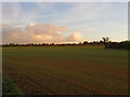
Lower Eight Acres
The name of the field according to the 1846 tithe map. The northern end of the field marks the course of the A27.
Image: © Simon Carey
Taken: 30 Oct 2010
0.08 miles
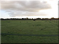
3
Mackralls Brook Field
The name of the field according to the 1846 tithe map that was once part of Walberton Common that was inclosed in 1769. The eponymous brook is in the wood beyond called Ashbeds.
Image: © Simon Carey
Taken: 30 Oct 2010
0.09 miles
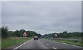
4
Beware horses on the A27
A bridleway crosses ahead. Just how well used it is for horses is not known - I've never seen one on several trips along this road.
Image: © Robin Webster
Taken: 23 Sep 2011
0.11 miles
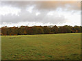
5
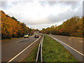
Arundel Road
The A27 given colour by the early morning light and the autumnal look of the trees lining the road. The road follows an old Roman route that once linked Pevensey castle to Chichester and since the days of the motor car has been the A27. This section was dualled in the late 1980s as part of the construction of the Fontwell by-pass.
Image: © Simon Carey
Taken: 30 Oct 2010
0.13 miles
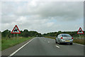
6
Barn Croft
The name of the field according to the 1846 tithe map and once part of Walberton Common that was inclosed in 1769. Many of the fields between the bridleway and Mill Road are now paddocks.
Image: © Simon Carey
Taken: 30 Oct 2010
0.15 miles
7
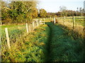
Public Bridleway 392
Route from Walberton to Slindon.
Image: © Peter Holmes
Taken: 6 Nov 2011
0.20 miles
8
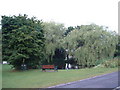
Walberton Duck Pond
West of the village centre.
Image: © Chris Shaw
Taken: Unknown
0.21 miles