IMAGES TAKEN NEAR TO
Ford Road, ARUNDEL, BN18 0FL
Introduction
This page details the photographs taken nearby to Ford Road, BN18 0FL by members of the Geograph project.
The Geograph project started in 2005 with the aim of publishing, organising and preserving representative images for every square kilometre of Great Britain, Ireland and the Isle of Man.

There are currently over 7.5m images from over14,400 individuals and you can help contribute to the project by visiting https://www.geograph.org.uk
Image Map
Images are licensed for reuse under creativecommons.org/licenses/by-sa/2.0
Notes
- Clicking on the map will re-center to the selected point.
- The higher the marker number, the further away the image location is from the centre of the postcode.
Image Listing (7 Images Found)
Images are licensed for reuse under creativecommons.org/licenses/by-sa/2.0
Image
Details
Distance
1
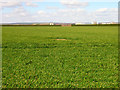
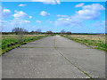
Ford Aerodrome
Looking across fields now being used as farmland once more towards the point where the east-west and north-south runways meet. Hedges now line the route of both.
Image: © Simon Carey
Taken: 21 Mar 2008
0.17 miles
2
Former Taxi Road, Ford Aerodrome
The junction in the foreground leads to an isolated hangar. The new buildings of Pages occupy parts of the old north-south runway.
Image: © Simon Carey
Taken: 21 Mar 2008
0.21 miles
3
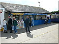
Ford Market near to Littlehampton.
Sunday market packed with stalls on a disused airfield.
Image: © Johnny Durnan
Taken: 19 Sep 2004
0.21 miles
4
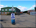
Rudford Industrial Estate
Built on the site of the hangars of the former Ford Aerodrome in 1969 and expanded during the 1980s.
Image: © Simon Carey
Taken: 21 Mar 2008
0.22 miles
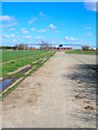
5
Former Taxi Road, Ford Aerodrome
Still complete from Rudford Industrial Estate to Burndell and currently the route of the footpath from Climping to Yapton.
Image: © Simon Carey
Taken: 21 Mar 2008
0.23 miles
6
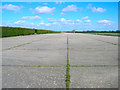
Runway, Ford Aerodrome
Originally opened in 1917 constructed by German POWs but closed by 1920. Between the wars it was home to a number of different aeronautical companies before being requesitioned by the RAF in 1939 and by the navy in 1945 who renamed it HMS Peregrine. They moved out in 1958 and for a time the airfield was used privately, one occupation being the construction of replica aircraft for the film industry, until finally being closed in 1980. The east-west runway has been used as the site of a big Sunday market since 1988 though it is now being threatened with plans to construct a 5000 house eco-village.
Image: © Simon Carey
Taken: 21 Mar 2008
0.24 miles
7
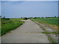
Footpath 175 on former taxiway
The route between Climping and Yapton crosses the remains of Ford aerodrome.
Image: © Peter Holmes
Taken: 5 Jun 2010
0.25 miles