IMAGES TAKEN NEAR TO
Nelson Row, Ford Road, ARUNDEL, BN18 0DD
Introduction
This page details the photographs taken nearby to Nelson Row, Ford Road, BN18 0DD by members of the Geograph project.
The Geograph project started in 2005 with the aim of publishing, organising and preserving representative images for every square kilometre of Great Britain, Ireland and the Isle of Man.

There are currently over 7.5m images from over14,400 individuals and you can help contribute to the project by visiting https://www.geograph.org.uk
Image Map
Images are licensed for reuse under creativecommons.org/licenses/by-sa/2.0
Notes
- Clicking on the map will re-center to the selected point.
- The higher the marker number, the further away the image location is from the centre of the postcode.
Image Listing (38 Images Found)
Images are licensed for reuse under creativecommons.org/licenses/by-sa/2.0
Image
Details
Distance
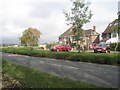
1
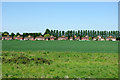
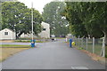
Nelson Row
These were built about 1938 as the beginning of a large-scale development. The Second World War and presumably post-war planning stopped further development. Nelson Row runs parallel with Ford Road, which is beyond the houses. Viewed from the Arun river wall.
Image: © Robin Webster
Taken: 24 May 2010
0.01 miles
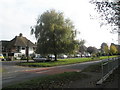
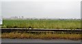
4
Nelsons Row, Ford
Viewed across the field from the banks of the River Arun. The houses were erected in 1938 and were intended to be the start of a large development that was prevented due to the start of the war and then by tougher planning laws post 1947.
Image: © Simon Carey
Taken: 21 Mar 2008
0.04 miles
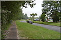
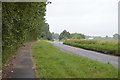
5
Looking across Ford Road into Nelson Row
Image: © Basher Eyre
Taken: 29 Oct 2009
0.06 miles
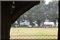
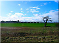
10
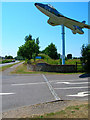
Entrance to Ford Airfield
The airfield was active between 1939 and 1958 when it was closed, part of the land becoming Ford Open Prison and the rest being used for either industrial purposes of left. This part is now the entrance to Ford Sunday Market.
Image: © Simon Carey
Taken: 2 Jul 2006
0.12 miles