IMAGES TAKEN NEAR TO
The Old Canal Basin, ARUNDEL, BN18 0BT
Introduction
This page details the photographs taken nearby to The Old Canal Basin, BN18 0BT by members of the Geograph project.
The Geograph project started in 2005 with the aim of publishing, organising and preserving representative images for every square kilometre of Great Britain, Ireland and the Isle of Man.

There are currently over 7.5m images from over14,400 individuals and you can help contribute to the project by visiting https://www.geograph.org.uk
Image Map
Images are licensed for reuse under creativecommons.org/licenses/by-sa/2.0
Notes
- Clicking on the map will re-center to the selected point.
- The higher the marker number, the further away the image location is from the centre of the postcode.
Image Listing (205 Images Found)
Images are licensed for reuse under creativecommons.org/licenses/by-sa/2.0
Image
Details
Distance
5
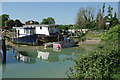
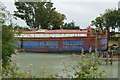
Houseboats, Ford
In a small bay off the Arun. Many have assumed this was the start of the long derelict Portsmouth and Arundel Canal. It wasn't. A study of older OS maps and consideration of where the visible remains of the first lock are will make this clear.
Image: © Robin Webster
Taken: 24 May 2010
0.01 miles
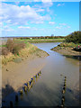
6

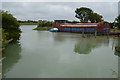
Course of old Portsmouth and Arundel Canal at Ford
In the enclosure below the present day river wall are the only visible remains of the first lock out of the River Arun. The position and form of the remains indicate that it was where the southern upper gate was. The next lock was close by the building just showing on the right. The two locks raised the canal 12 ft above the level of high water spring tides in the Arun, in steps of 5 ft and 7 ft. So this first lock, more often than not, had a bigger rise. The canal had a navigable depth near 5 ft, so the remains, which are at the bottom of the upper gate, were a little below the level of high water spring tides. The canal would have been on or in an embankment about 6 ft above high water springs, this has been removed or buried under the modern river wall.
Image: © Robin Webster
Taken: 24 May 2010
0.01 miles
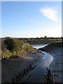
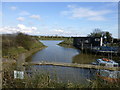
7
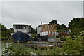
Ford Canal Basin
Remnant of the old Portsmouth-Arundel Canal where it joined the River Arun. There were two locks and a water pumping station here whilst the canal headed off out of the picture to the right. This part was the first to built in 1818 but had been abandoned after 1847. The basin is now home to four houseboats out of picture to the right.
Image: © Simon Carey
Taken: 21 Mar 2008
0.02 miles
8
Binsted Brook
Travelling through the old canal basin towards its confluence with the River Arun. The Arundel-Portsmouth canal was opened in 1823 from an original idea during the Napoleonic Wars by the Royal Navy to provide a link between Portsmouth and London without having to use the English Channel. Never a successful venture part of its raison d'etre was lost with the end of war in 1815 and whatever trade used it virtually ceased overnight with the coming of the railway in 1846. The last known cargo to use the canal was in 1847 and the bed had dried up by 1862. The only section to survive was the branch to Chichester which is still there today. The canal originally joined the confluence of the brook and the river at this point though only the basin now remains as a reminder.
Image: © Simon Carey
Taken: 24 Oct 2010
0.02 miles
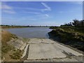
10
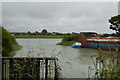
Inlet off the River Arun
This was the last section of the Portsmouth and Arundel Canal,which closed in 1847, where it joined the River Arun.
Image: © Dave Spicer
Taken: 19 Mar 2013
0.02 miles