IMAGES TAKEN NEAR TO
Hollingbury Road, BRIGHTON, BN1 7JD
Introduction
This page details the photographs taken nearby to Hollingbury Road, BN1 7JD by members of the Geograph project.
The Geograph project started in 2005 with the aim of publishing, organising and preserving representative images for every square kilometre of Great Britain, Ireland and the Isle of Man.

There are currently over 7.5m images from over14,400 individuals and you can help contribute to the project by visiting https://www.geograph.org.uk
Image Map
Images are licensed for reuse under creativecommons.org/licenses/by-sa/2.0
Notes
- Clicking on the map will re-center to the selected point.
- The higher the marker number, the further away the image location is from the centre of the postcode.
Image Listing (89 Images Found)
Images are licensed for reuse under creativecommons.org/licenses/by-sa/2.0
Image
Details
Distance

3

Fiveways, Ditchling Road, Fiveways, Brighton
Up until very recently this was the Stanmer Park Tavern originally opened as a hotel in the 1880s. The name change probably came about due to an unsavoury reputation it picked up around the turn of the century. I certainly never remember it being a problem when I used it in the late 1980s.
Image: © Simon Carey
Taken: 4 Oct 2015
0.05 miles
4

The Pub at Fiveways
On the corner of Hollingbury Road and Ditchling Road in Brighton.
Image: © Mat Fascione
Taken: 22 Aug 2022
0.05 miles
5

The Stanmer Park, Ditchling Road / Hollingbury Road, BN1
Image: © Mike Quinn
Taken: 25 Jun 2014
0.05 miles
6
Hollingbury Crescent, Hollingdean, Brighton
The road links Hollingbury Road with the crossroads at Hollingdean Terrace with the road continuining as Hollingbury Place. It was developed between 1910 and 1914 and descends into what was once Cowley's Bottom containing a single building, Harrington Farm. The valley was developed from 1900 and again in the 1920s with the eastern slope competed in the 1950s. The suburb of Hollingdean is roughly bounded by Hollingbury Road in the west, Hollingdean Road to the south and the railway line to the east. To the north is open downland containing Hollingbury Park Golf Course.
Image: © Simon Carey
Taken: 4 Oct 2015
0.05 miles
7
Sign for The Stanmer Park, Ditchling Road / Hollingbury Road, BN1
See Image
Image: © Mike Quinn
Taken: 25 Jun 2014
0.06 miles
8
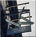
Sign at the Pub at Fiveways
At the junction of Hollingbury Road, Ditchling Road, Preston Drove and Stanford Avenue in Brighton.
Image: © Mat Fascione
Taken: 22 Aug 2022
0.06 miles