IMAGES TAKEN NEAR TO
Beal Crescent, BRIGHTON, BN1 7BU
Introduction
This page details the photographs taken nearby to Beal Crescent, BN1 7BU by members of the Geograph project.
The Geograph project started in 2005 with the aim of publishing, organising and preserving representative images for every square kilometre of Great Britain, Ireland and the Isle of Man.

There are currently over 7.5m images from over14,400 individuals and you can help contribute to the project by visiting https://www.geograph.org.uk
Image Map
Images are licensed for reuse under creativecommons.org/licenses/by-sa/2.0
Notes
- Clicking on the map will re-center to the selected point.
- The higher the marker number, the further away the image location is from the centre of the postcode.
Image Listing (32 Images Found)
Images are licensed for reuse under creativecommons.org/licenses/by-sa/2.0
Image
Details
Distance
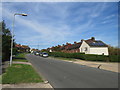
1
The Crestway, Hollingdean, Brighton
The Crestway in Hollingdean, a suburb of Brighton.
Image: © Malc McDonald
Taken: 24 Aug 2019
0.06 miles
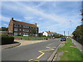
2
The Crestway. Hollingdean, Brighton
Low-rise blocks of flats on The Crestway in Hollingbury, a residential road in Brighton's suburbs.
Image: © Malc McDonald
Taken: 24 Aug 2019
0.09 miles
3
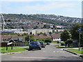
Thompson Road, Hollingdean, Brighton
Thompson Road descends a steep gradient in Hollingdean, in the suburbs of Brighton.
Image: © Malc McDonald
Taken: 24 Aug 2019
0.09 miles
4
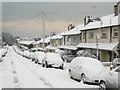
Dudley Road in thick snow
This is one of many hundreds of similar side roads in Brighton which have not been gritted or cleared of snow.
Image: © Peter Whitcomb
Taken: 18 Dec 2009
0.12 miles
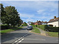
5
Davey Drive, Hollingdean, Brighton
Davey Drive is a residential road which climbs a hill in Hollingdean, a suburb of Brighton.
Image: © Malc McDonald
Taken: 24 Aug 2019
0.12 miles
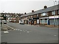
6
Dudley Road, Hollingdean, Brighton
A residential road that runs between Roedale Road to the south and Hollingbury Place to the north that was developed in the late 1920s.
Image: © Simon Carey
Taken: 4 Oct 2015
0.13 miles
7

Chapel of the Holy Family, Hollingdean Street, Hollingdean, Brighton
Built in 2002 and home to the Society of St Pius X , an unofficial priestly catholic society who have been in schism with the Holy See since 1988.
Image: © Simon Carey
Taken: 4 Oct 2015
0.15 miles
8
The Crestway, Hollingdean, Brighton
The Crestway is a residential road on a steep hill in Hollingbury, a suburb of Brighton.
Image: © Malc McDonald
Taken: 24 Aug 2019
0.16 miles
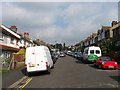
9
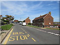
Shops in Hollingbury Place
On the Hollingdean estate
Image: © Paul Gillett
Taken: 20 Feb 2011
0.16 miles
10

Roedale Road, Hollingdean, Brighton
Running along the floor of the former Cowley's Bottom and developed from the late 1890s onwards. The road runs between Upper Hollingdean Road and Hollingbury Place.
Image: © Simon Carey
Taken: 4 Oct 2015
0.17 miles