IMAGES TAKEN NEAR TO
Lyminster Road, LITTLEHAMPTON, BN17 7QE
Introduction
This page details the photographs taken nearby to Lyminster Road, BN17 7QE by members of the Geograph project.
The Geograph project started in 2005 with the aim of publishing, organising and preserving representative images for every square kilometre of Great Britain, Ireland and the Isle of Man.

There are currently over 7.5m images from over14,400 individuals and you can help contribute to the project by visiting https://www.geograph.org.uk
Image Map (Loading...)


Getting Data...Please wait
Leaflet Map data © OpenStreetMap
Images are licensed for reuse under creativecommons.org/licenses/by-sa/2.0
Notes
- Clicking on the map will re-center to the selected point.
- The higher the marker number, the further away the image location is from the centre of the postcode.
Image Listing (84 Images Found)
Images are licensed for reuse under creativecommons.org/licenses/by-sa/2.0
Image
Details
Distance
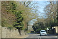
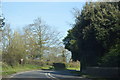
4
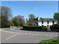
Corner House, Lyminster Road
The main A284 from Crossbush to Littlehampton performs two 90 degree turns as it heads through Lyminster this is the second and gives some indication how tight it is. Taken from the junction with Church Lane.
Image: © Simon Carey
Taken: 13 Apr 2009
0.07 miles
7
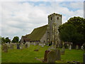
Lyminster Church
St Mary Magdalene Church, Lyminster
Image: © Janine Forbes
Taken: 12 Jun 2005
0.13 miles
8
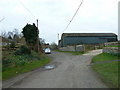
Looking down Church Lane towards the farm
Image: © Basher Eyre
Taken: 1 Mar 2011
0.13 miles
9
Barn near Lyminster House
Viewed from the entrance on the A284.
Image: © Simon Carey
Taken: 13 Apr 2009
0.13 miles
10
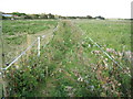
Lyminster: Public footpath
This little-used public footpath cuts off the corner of Lyminster Road where it makes a double right-angled turn through the village. The path is shown on the Ordnance Survey map of 1879 at which time Lyminster was, according to the OS, definitely spelt Leominster. Today the path is defined on the ground by nothing more than some bands of electric fencing separating various paddocks for horses.
Image: © Nigel Cox
Taken: 17 Sep 2009
0.14 miles