IMAGES TAKEN NEAR TO
Woodcote Lane, LITTLEHAMPTON, BN17 7PT
Introduction
This page details the photographs taken nearby to Woodcote Lane, BN17 7PT by members of the Geograph project.
The Geograph project started in 2005 with the aim of publishing, organising and preserving representative images for every square kilometre of Great Britain, Ireland and the Isle of Man.

There are currently over 7.5m images from over14,400 individuals and you can help contribute to the project by visiting https://www.geograph.org.uk
Image Map
Images are licensed for reuse under creativecommons.org/licenses/by-sa/2.0
Notes
- Clicking on the map will re-center to the selected point.
- The higher the marker number, the further away the image location is from the centre of the postcode.
Image Listing (9 Images Found)
Images are licensed for reuse under creativecommons.org/licenses/by-sa/2.0
Image
Details
Distance
1
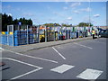
Waste recycling centre
Littlehampton Household Waste Recycling centre, Mill Lane, Littlehampton.
Image: © Peter Holmes
Taken: 29 Oct 2007
0.05 miles
2
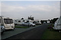
Littlehampton Caravan Club site
Image: © Jo and Steve Turner
Taken: 20 Sep 2009
0.11 miles
3
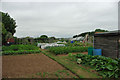
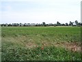
Allotments, Wick
The local speciality of market gardening is carried on here on a small scale, but no less effectively.
Image: © Robin Webster
Taken: 2 Jul 2010
0.11 miles
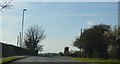
4
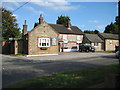
Wick: The Six Bells
In the 18th century this flint and brick building was a coaching inn standing in isolation on the road between Littlehampton and Arundel. The urban sprawl of Littlehampton, including mobile home parks, has now spread up to it and beyond and the road is now the A284 Lyminster Road.
Image: © Nigel Cox
Taken: 17 Sep 2009
0.18 miles
5
Glasshouses of Toddington
Part of Holyacre Farm according to the OS map. These are best seen from the railway line that passes closer. Taken from the bridleway between Lyminster and Poling
Image: © Bob Embleton
Taken: 21 Jun 2006
0.19 miles
7
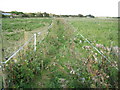
Lyminster: Public footpath
This little-used public footpath cuts off the corner of Lyminster Road where it makes a double right-angled turn through the village. The path is shown on the Ordnance Survey map of 1879 at which time Lyminster was, according to the OS, definitely spelt Leominster. Today the path is defined on the ground by nothing more than some bands of electric fencing separating various paddocks for horses.
Image: © Nigel Cox
Taken: 17 Sep 2009
0.21 miles

9
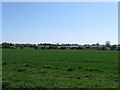
Glasshouses at Toddington
Viewed from the bridleway that links Lyminster to Poling. Much of the coastal plain between the South Downs and the sea has historically been involved in the market garden industry. The line of bushes at the end of the field marks the course of Black Ditch a tributary of the River Arun.
Image: © Simon Carey
Taken: 13 Apr 2009
0.23 miles