IMAGES TAKEN NEAR TO
Tower Gate, BRIGHTON, BN1 6TU
Introduction
This page details the photographs taken nearby to Tower Gate, BN1 6TU by members of the Geograph project.
The Geograph project started in 2005 with the aim of publishing, organising and preserving representative images for every square kilometre of Great Britain, Ireland and the Isle of Man.

There are currently over 7.5m images from over14,400 individuals and you can help contribute to the project by visiting https://www.geograph.org.uk
Image Map
Images are licensed for reuse under creativecommons.org/licenses/by-sa/2.0
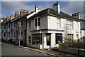
Notes
- Clicking on the map will re-center to the selected point.
- The higher the marker number, the further away the image location is from the centre of the postcode.
Image Listing (126 Images Found)
Images are licensed for reuse under creativecommons.org/licenses/by-sa/2.0
Image
Details
Distance
1
Pinewood Close
Modern cul-de-sac off Station Road built in the grounds of a former pleasure garden called Tivoli Gardens that operated between 1831-88.
Image: © Simon Carey
Taken: 25 Oct 2009
0.04 miles
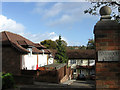
2
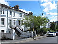
Tower House, London Road
Built in 1902 on the site of the former Tivoli pleasure gardens. One of the few surviving large houses/villas that were built by the wealthy along what is now the A23 between Preston and Patcham. Now converted into a council day centre.
Image: © Simon Carey
Taken: 24 Nov 2007
0.05 miles
3
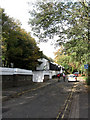
Station Road
The public road ends beyond the houses where it becomes a private track called Snakey Lane.
Image: © Simon Carey
Taken: 25 Oct 2009
0.05 miles
4
Platform Three, Preston Park Station
The eastern island platform now only has side open to passengers, the rails on what was platform four on the right have now been lifted.
Image: © Simon Carey
Taken: 25 Oct 2009
0.07 miles
6
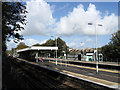
Preston Park Station
The first stop out of Brighton was only opened in 1869 as Preston to serve the recently constructed estates around the old village of Preston. Its current name dates from 1879 when the Cliftonville Spur was opened and the station rebuilt as two island platforms. This station building survived until the 1970s when it was pulled down and replaced by the current plain set up. Taken from the walkway that connects Woodside Avenue to the station via a subway.
Image: © Simon Carey
Taken: 25 Oct 2009
0.08 miles
7
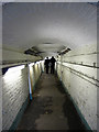
Subway, Preston Park Station
Linking the island platforms above with entrances from Woodside Avenue in the west and Clermont Road in the east. There isn't much room height or width wise, particularly beyond the two men who are standing by the steps that lead to the platform for London trains.
Image: © Simon Carey
Taken: 25 Oct 2009
0.08 miles
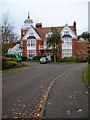
8
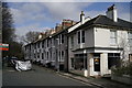
Preston Park
Housing in Station Road.
Image: © Peter Trimming
Taken: 9 Mar 2020
0.08 miles
9
Preston Park
Junction of Station Road and Clermont Road.
Image: © Peter Trimming
Taken: 9 Mar 2020
0.08 miles
10
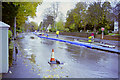
A23 closed by floods, November 2000
Building a road along the bottom of a "dry" chalk valley is satisfactory most of the time, but sometimes ... The authorities attempted to capture the bourn with pumps and hoses and bypass the worst section, but with limited success.
Image: © Robin Webster
Taken: Unknown
0.08 miles