IMAGES TAKEN NEAR TO
Ashford Road, BRIGHTON, BN1 6LL
Introduction
This page details the photographs taken nearby to Ashford Road, BN1 6LL by members of the Geograph project.
The Geograph project started in 2005 with the aim of publishing, organising and preserving representative images for every square kilometre of Great Britain, Ireland and the Isle of Man.

There are currently over 7.5m images from over14,400 individuals and you can help contribute to the project by visiting https://www.geograph.org.uk
Image Map
Images are licensed for reuse under creativecommons.org/licenses/by-sa/2.0
Notes
- Clicking on the map will re-center to the selected point.
- The higher the marker number, the further away the image location is from the centre of the postcode.
Image Listing (67 Images Found)
Images are licensed for reuse under creativecommons.org/licenses/by-sa/2.0
Image
Details
Distance

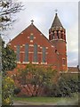
2

St Matthias Church at Fiveways, Brighton
Image: © Mat Fascione
Taken: 22 Aug 2022
0.08 miles
3
St Matthias Church
Located in Hollingbury Park Avenue
Image: © Paul Gillett
Taken: 19 Sep 2010
0.11 miles
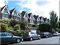
4

Houses on Ditchling Road
Next to Hollingbury Golf Course
Image: © Paul Gillett
Taken: 20 Feb 2011
0.12 miles
5

Ditchling Road from Five Ways Junction
In the centre of a pentagon shaped spiders web of roads. Looking north towards Hollingbury Hill Fort.
Image: © Bob Embleton
Taken: 11 Sep 2005
0.13 miles
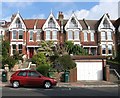
6

Ditchling Road, Fiveways, Brighton
One of the old London-Brighton roads which went via Ditchling Beacon, Lindfield and Godstone and one of the longest named, beginning on The Level, TQ 30 06, then beyond the city boundaries to Ditchling Beacon, TQ 32 16. Fiveways is the name of the junction and is often used locally for the surrounding district located at a point where Preston ends and Hollingdean, which lies in a valley to the east, begins. The junction consists of Ditchling Road that runs from south to north, Preston Drove heading west to Preston village and the A23, Stanford Avenue heading south west also to the A23, and Hollingbury Road that heads east then south to Hollingdean Road. Prior to the 1880s the junction just consisted of a track to Preston.
Image: © Simon Carey
Taken: 4 Oct 2015
0.13 miles
7
Preston Drove, BN1 (3)
North side, between Southdown Avenue and Edburton Avenue.
Image: © Mike Quinn
Taken: 25 Jun 2014
0.13 miles
8
209-215, Preston Drove, Preston, Brighton
Part of a long terrace that is numbered 157 through to 259 that was developed in the early 1900s on the northern side of Preston Drove.
Image: © Simon Carey
Taken: 4 Oct 2015
0.13 miles
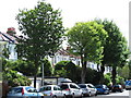
9

Start of path through the woods
The beginning of paths through the wooded slope below Hollingbury Park.
Image: © Robin Webster
Taken: 30 Apr 2010
0.14 miles
10
Preston Drove, BN1 (2)
North side, opposite Blakers Park.
Image: © Mike Quinn
Taken: 25 Jun 2014
0.14 miles