IMAGES TAKEN NEAR TO
Church Hill, LITTLEHAMPTON, BN16 4EG
Introduction
This page details the photographs taken nearby to Church Hill, BN16 4EG by members of the Geograph project.
The Geograph project started in 2005 with the aim of publishing, organising and preserving representative images for every square kilometre of Great Britain, Ireland and the Isle of Man.

There are currently over 7.5m images from over14,400 individuals and you can help contribute to the project by visiting https://www.geograph.org.uk
Image Map
Images are licensed for reuse under creativecommons.org/licenses/by-sa/2.0
Notes
- Clicking on the map will re-center to the selected point.
- The higher the marker number, the further away the image location is from the centre of the postcode.
Image Listing (60 Images Found)
Images are licensed for reuse under creativecommons.org/licenses/by-sa/2.0
Image
Details
Distance
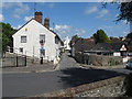
1
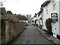
Church Road
Old area of the village connecting the Lamb Inn with St Margaret's Church. The road itself has had a number of names over the years, some alluding to the nearby church such as Lane, Row and Walk, from the 19th century it became known as Bakers Row after the family who owned most the property in the street.
Image: © Simon Carey
Taken: 13 Apr 2009
0.01 miles
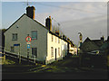
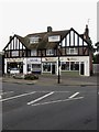
3
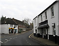
Shops, Arundel Road
The main village commercial centre is around The Square where Arundel Road, Station Road, High Street and Water Lane meet.
Image: © Simon Carey
Taken: 13 Apr 2009
0.01 miles
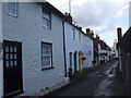
4
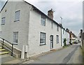
Angmering, Church Road
A narrow road from The Square to St. Margaret's, lined with C18 flint-faced cottages. Nos 1-5 are C18, and Grade II listed by Historic England: https://historicengland.org.uk/listing/the-list/list-entry/1027715
Image: © Mike Faherty
Taken: 13 Apr 2019
0.02 miles
8
Church Road, Angmering
Taken from Arundel Road.
Image: © Slbs
Taken: 21 Dec 2006
0.02 miles
9
Shops, Arundel Road
On the western side of the road as it reaches the junction with The Square.
Image: © Simon Carey
Taken: 13 Apr 2009
0.03 miles
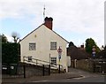
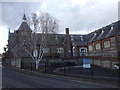
10
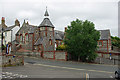
The old school, Angmering
This wonderful Victorian confection is dated 1853.
Image: © Robin Webster
Taken: 2 Jul 2010
0.03 miles