IMAGES TAKEN NEAR TO
High Street, LITTLEHAMPTON, BN16 4AH
Introduction
This page details the photographs taken nearby to High Street, BN16 4AH by members of the Geograph project.
The Geograph project started in 2005 with the aim of publishing, organising and preserving representative images for every square kilometre of Great Britain, Ireland and the Isle of Man.

There are currently over 7.5m images from over14,400 individuals and you can help contribute to the project by visiting https://www.geograph.org.uk
Image Map
Images are licensed for reuse under creativecommons.org/licenses/by-sa/2.0
Notes
- Clicking on the map will re-center to the selected point.
- The higher the marker number, the further away the image location is from the centre of the postcode.
Image Listing (30 Images Found)
Images are licensed for reuse under creativecommons.org/licenses/by-sa/2.0
Image
Details
Distance
1
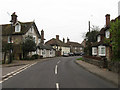
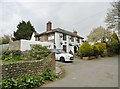
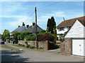
High Street
The flint house on the left is Gothic House whilst the weatherboarded house is Brocketts which dates from the 16th century. Taken from the junction with Weavers Ring.
Image: © Simon Carey
Taken: 13 Apr 2009
0.07 miles
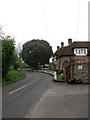
2
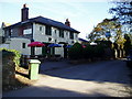
The Spotted Cow, Angmering
Country pub at 1 High Street, Angmering,and annual venue for summer Solstice meeting of the Sompting Village Morris. http://www.somptingvillagemorris.org.uk/
Image: © Peter Holmes
Taken: 12 Nov 2007
0.08 miles
3
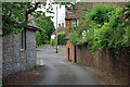
Looking out of Mill Lane, Angmering
A short dead-end with very limited space to turn a car, unless a resident.
Image: © Robin Webster
Taken: 20 Jun 2010
0.08 miles
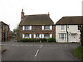
5
Angmering, Spotted Cow
Public house at the eastern end of High Street. Internally, a small bar right, dining left and central counter; darts, outdoor seating at front. Six cask ales on offer. The C19 building is Grade II listed by Historic England: https://historicengland.org.uk/listing/the-list/list-entry/1353862
Image: © Mike Faherty
Taken: 13 Apr 2019
0.09 miles
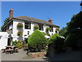
6
The Malthouse, Weavers Hill
Weavers Hill is one of the older roads in the village linking High Street with Water Lane.
Image: © Simon Carey
Taken: 13 Apr 2009
0.10 miles
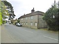
7
The Old House, High Street
Viewed from Weavers Hill. To the left is Old Mill Lane and to the right Bennington House. The cottage was previously known as East End Cottage.
Image: © Simon Carey
Taken: 13 Apr 2009
0.10 miles
8
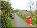
Angmering, bridleway
From the eastern end of High Street, over A280 and on to Ferring.
Image: © Mike Faherty
Taken: 13 Apr 2019
0.13 miles
9
Angmering Cottages
Cottages at the road junction near the north of the square
Image: © Chris Shaw
Taken: Unknown
0.13 miles
10
Angmering, cottages
Bow Cottage (left) and Salters, on High Street; early C19 and Grade II listed by Historic England: https://historicengland.org.uk/listing/the-list/list-entry/1353840
Image: © Mike Faherty
Taken: 13 Apr 2019
0.14 miles