IMAGES TAKEN NEAR TO
The Drills, High Street, LITTLEHAMPTON, BN16 4AD
Introduction
This page details the photographs taken nearby to The Drills, High Street, BN16 4AD by members of the Geograph project.
The Geograph project started in 2005 with the aim of publishing, organising and preserving representative images for every square kilometre of Great Britain, Ireland and the Isle of Man.

There are currently over 7.5m images from over14,400 individuals and you can help contribute to the project by visiting https://www.geograph.org.uk
Image Map
Images are licensed for reuse under creativecommons.org/licenses/by-sa/2.0
Notes
- Clicking on the map will re-center to the selected point.
- The higher the marker number, the further away the image location is from the centre of the postcode.
Image Listing (65 Images Found)
Images are licensed for reuse under creativecommons.org/licenses/by-sa/2.0
Image
Details
Distance
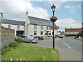
1
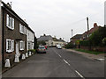
Ivy and Thorpe Cottages, High Street
Ivy is the nearest to the camera and is on the corner of Honey Lane.
Image: © Simon Carey
Taken: 13 Apr 2009
0.02 miles
2
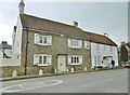
Angmering, cottages
Ivy Cottage (left) and Thorpe Cottage, on High Street; C18 and Grade II listed by Historic England: https://historicengland.org.uk/listing/the-list/list-entry/1276846
Image: © Mike Faherty
Taken: 13 Apr 2019
0.03 miles
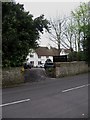
3
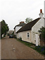
Honey Lane
Old lane leading south from the High Street onto what was once agricultural land. The lane is now a private road.
Image: © Simon Carey
Taken: 13 Apr 2009
0.04 miles
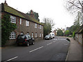
4
High Street
Heading down to the village centre around The Square.
Image: © Simon Carey
Taken: 13 Apr 2009
0.07 miles
5
Angmering Manor Hotel
Hotel on High Street, Angmering.
Image: © G Laird
Taken: 17 Jul 2019
0.07 miles
6
Angmering Manor Hotel
The building has only been a hotel since 2006, its origins date back to the 1570s when it was built as a rectory and remained in use until 1922 when it became a residential property renamed Glebe House. It was sold in the 1950s to the Vocation Order of Syon, renamed Syon House, and became a convalescent home for nuns until they departed in 1998. Extensive refurbishments occurred in the 19th century when the wooden framing was covered and again in the early part of this century to convert it into a luxury hotel. Viewed from the High Street.
Image: © Simon Carey
Taken: 13 Apr 2009
0.07 miles
7
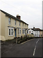
Bow and Salter Cottages, High Street
Bow to the left, Salter to the right, built in the early 19th century.
Image: © Simon Carey
Taken: 13 Apr 2009
0.07 miles
8
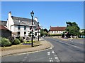
Water Lane, Angmering
Angmering is a large village between Littlehampton and Worthing just to the south of the A27 and about 1½ miles north of the English Channel. This view is at the junction of Arundel Road (left) and High Street (right).
Image: © G Laird
Taken: 16 Jul 2019
0.09 miles
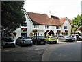
9
Angmering, Lamb
Former coaching inn on The Square. Two rooms downstairs: left, dining, right, drinking, with central counter, old village photos on walls, large open fireplace and some old wooden beams; accommodation. Cask ales on offer: Fuller's London Pride, Greyhound Amber Eyes & Old Village. The building is C18, and Grade II listed by Historic England: https://historicengland.org.uk/listing/the-list/list-entry/1027684
Image: © Mike Faherty
Taken: 13 Apr 2019
0.09 miles
10
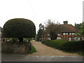
Chants Cottage, High Street
A 15th century timber and brick building built back from the main village street unlike many other of the older houses on this street. Probably a former farmhouse, the driveway to the left was once known as Chants Lane and perhaps accessed the fields to the rear.
Image: © Simon Carey
Taken: 13 Apr 2009
0.09 miles