IMAGES TAKEN NEAR TO
Highcroft Villas, BRIGHTON, BN1 5PZ
Introduction
This page details the photographs taken nearby to Highcroft Villas, BN1 5PZ by members of the Geograph project.
The Geograph project started in 2005 with the aim of publishing, organising and preserving representative images for every square kilometre of Great Britain, Ireland and the Isle of Man.

There are currently over 7.5m images from over14,400 individuals and you can help contribute to the project by visiting https://www.geograph.org.uk
Image Map
Images are licensed for reuse under creativecommons.org/licenses/by-sa/2.0
Notes
- Clicking on the map will re-center to the selected point.
- The higher the marker number, the further away the image location is from the centre of the postcode.
Image Listing (158 Images Found)
Images are licensed for reuse under creativecommons.org/licenses/by-sa/2.0
Image
Details
Distance
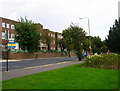
1
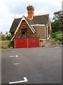
North Lodge, Old Mill Mews
One of two lodges built for the house, Highcroft, constructed in 1876. This lodge faced onto Highcroft Villas whilst South Lodge was based on Dyke Road. Highcroft still stands but is obscured from view by the Territorial Army depot. Taken from Old Mill Mews.
Image: © Simon Carey
Taken: 29 Aug 2007
0.04 miles
2
Entrance to Stanford Infants School, Highcroft Villas
The tilt of the picture is the result of the slope that Highcroft Villas descends from. The school itself was built in the 1970s to ease overcrowding in Stanford School to the south, the infants coming here and the juniors staying at the older site.
Image: © Simon Carey
Taken: 29 Aug 2007
0.05 miles
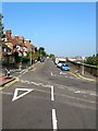
3
Highcroft Villas
The road links Dyke Road to Dyke Road Drive and was developed in the 1880s as an upmarket residential area.
Image: © Simon Carey
Taken: 12 Mar 2013
0.06 miles
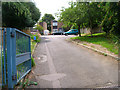
4
Old Mill Mews
A converted workshop behind Dyke Road. The workshop itself stood on the site of Preston Mill a windmill originally built on the site of Regency Square near the coast but was moved by a team of 36 oxen in 1797 to this position. The mill survived until 1881 when it was demolished the site then used as a builders yard. Recently, the garages and workshops have inturn been demolished and replaced by a small terrace of houses out of picture to the left.
Image: © Simon Carey
Taken: 29 Aug 2007
0.07 miles
5
Territorial Army Centre, Dyke Road
Originally erected as a drill hall during the Second World War to replace older and inadequate ones in the centre of town. Part of its grounds includes Highcroft House whose two lodges are now separate homes.
Image: © Simon Carey
Taken: 29 Aug 2007
0.08 miles
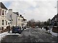
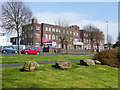
6
Highcroft Villas, Brighton
A residential road that runs from Dyke Road to this junction with Port Hall Avenue, Stanford Road and Dyke Road Drive that was developed between 1880-84 roughly at a similar time when the sidings of the railway were extended. The junction is one that can confuse those not familiar with it with the general flow of traffic going from Dyke Road Drive into Highcroft Villas. Not surprisingly many a perplexed learner driver can be found here. A popular road with fine views across the railway to Preston Park.
Image: © Simon Carey
Taken: 4 Oct 2015
0.08 miles
7
Quebec Barracks, Brighton
On Dyke Road.
Image: © Robin Webster
Taken: 13 Apr 2019
0.09 miles
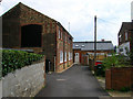
8

Derelict Railway Sheds
Located in the area between the junction of the main London-Brighton railway line and the Cliftonville Spur these sheds are now very dilapidated and no longer used. The view was taken from Millers Road and looks east between the gap of two sets of terraced housing and also gives an indication of the original scale of the excavation into the side of the chalk downs made by the railway. The green area beyond the sheds marks Preston Park.
Image: © Simon Carey
Taken: 11 Mar 2006
0.09 miles
9
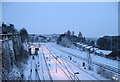
London-Brighton Line
Snowy view of Image though the former sheds have now been demolished.
Image: © Simon Carey
Taken: 2 Feb 2009
0.10 miles
10
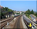
London-Brighton Railway
Viewed from Image with the mainline in the centre and the northern extent of the Lowers Walk sidings either side. The latter were added in the 1880s. The open space on the left beyond the parked train was once the site of former carriage sheds which were removed about seven years ago.
Image: © Simon Carey
Taken: 4 Oct 2015
0.10 miles