IMAGES TAKEN NEAR TO
Hampstead Road, BRIGHTON, BN1 5NG
Introduction
This page details the photographs taken nearby to Hampstead Road, BN1 5NG by members of the Geograph project.
The Geograph project started in 2005 with the aim of publishing, organising and preserving representative images for every square kilometre of Great Britain, Ireland and the Isle of Man.

There are currently over 7.5m images from over14,400 individuals and you can help contribute to the project by visiting https://www.geograph.org.uk
Image Map
Images are licensed for reuse under creativecommons.org/licenses/by-sa/2.0
Notes
- Clicking on the map will re-center to the selected point.
- The higher the marker number, the further away the image location is from the centre of the postcode.
Image Listing (200 Images Found)
Images are licensed for reuse under creativecommons.org/licenses/by-sa/2.0
Image
Details
Distance
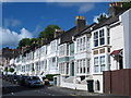
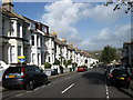
1
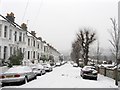
Hampstead Road
Residential road running downhill from The Drove towards Preston Park station. Needless to say with the snow on the ground other than those walking on the road in the distance there was not much evidence of traffic on this day. The slope of the hill means there is little housing on the southern side, the wall on the right separates the rear of the houses in Kingsley Road which runs parallel.
Image: © Simon Carey
Taken: 20 Jan 2013
0.01 miles
3
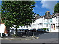
Robertson Road / Kingsley Road, BN1 (2)
Shows the location of Image
Image: © Mike Quinn
Taken: 25 Jun 2014
0.03 miles
6
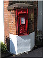
Edward VII postbox, Robertson Road / Kingsley Road, BN1
Image: © Mike Quinn
Taken: 25 Jun 2014
0.04 miles
7
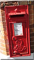
Edward VII postbox, Robertson Road / Kingsley Road, BN1 (2)
Image: © Mike Quinn
Taken: 25 Jun 2014
0.04 miles
8
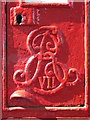
Edward VII postbox, Robertson Road / Kingsley Road, BN1 - royal cipher
Image: © Mike Quinn
Taken: 25 Jun 2014
0.04 miles
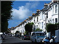
9
Hampstead Road
Residential road linking The Drove with Preston Park station below that was developed in the early 1890s. The South Downs are just visible in the background.
Image: © Simon Carey
Taken: 25 Oct 2009
0.04 miles
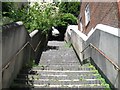
10
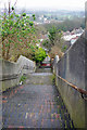
An impressive flight of steps
Linking Tivoli Crescent (top) with Hampstead Road (bottom). Only the fit use these steps in the upward direction!
Image: © Robin Webster
Taken: 7 Apr 2010
0.04 miles