IMAGES TAKEN NEAR TO
Old Shoreham Road, BRIGHTON, BN1 5DQ
Introduction
This page details the photographs taken nearby to Old Shoreham Road, BN1 5DQ by members of the Geograph project.
The Geograph project started in 2005 with the aim of publishing, organising and preserving representative images for every square kilometre of Great Britain, Ireland and the Isle of Man.

There are currently over 7.5m images from over14,400 individuals and you can help contribute to the project by visiting https://www.geograph.org.uk
Image Map
Images are licensed for reuse under creativecommons.org/licenses/by-sa/2.0
Notes
- Clicking on the map will re-center to the selected point.
- The higher the marker number, the further away the image location is from the centre of the postcode.
Image Listing (305 Images Found)
Images are licensed for reuse under creativecommons.org/licenses/by-sa/2.0
Image
Details
Distance
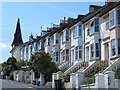
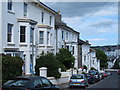
4

York Villas
Built at the same time as the Prestonville suburb on land once part of New England Farm whose 19th century farmhouse is now number 26 York Villas. The big white buildings are part of the new New England Quarter being constructed on the site of the former locomotive works whilst the grandstand of Brighton Racecourse can be seen on the horizon.
Image: © Simon Carey
Taken: 26 Aug 2007
0.03 miles
5
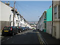
Brighton: Brigden Street
Image is visible as the distinct double line of trees on the far hillside.
Image: © Nigel Cox
Taken: 8 Jun 2008
0.03 miles
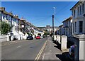
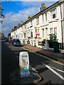
6
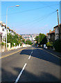
Old Shoreham Road
Former A27 now A270 has long been a major east west route in the area. Part of its course follows an old local Roman road which continued to be used for over a thousand years. This part climbs from the railway tunnel below with Prestonville Terrace lining the northern side of the road.
Image: © Simon Carey
Taken: 26 Aug 2007
0.04 miles
7
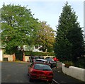
26, York Villas, Brighton
Beyond the gate and partially obscured by foliage is number 26 which dates from the early 1810s and was originally the farmhouse for New England Farm. It ceased working in the 1860s and was engulfed in the suburban advance of Brighton though the name lives on in a couple of street names.
Image: © Simon Carey
Taken: 25 Oct 2015
0.04 miles
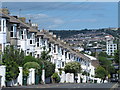
10
Prestonville Road
Developed in the 1860s by Daniel Friend as part of a middle class suburb called Prestonville. This view looks towards the junction with the A270 with Stanford Road beyond.
Image: © Simon Carey
Taken: 26 Aug 2007
0.04 miles