IMAGES TAKEN NEAR TO
Western Close, LANCING, BN15 8RU

Introduction

This page details the photographs taken nearby to Western Close, BN15 8RU by members of the Geograph project.

The Geograph project started in 2005 with the aim of publishing, organising and preserving representative images for every square kilometre of Great Britain, Ireland and the Isle of Man.

There are currently over 7.5m images from over14,400 individuals and you can help contribute to the project by visiting https://www.geograph.org.uk

Image Map


Images are licensed for reuse under creativecommons.org/licenses/by-sa/2.0
Notes
  • Clicking on the map will re-center to the selected point.
  • The higher the marker number, the further away the image location is from the centre of the postcode.

Image Listing (46 Images Found)

Images are licensed for reuse under creativecommons.org/licenses/by-sa/2.0
  • ...
Image
Details
Distance
1
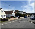
Housing near South Lancing, West Sussex
The houses are in Western Road, by the boating lake in Brooklands Park. The scene was seen from the top deck of a bus in Brighton Road (A259).
Image: © Roger D Kidd Taken: 1 Jan 2013
0.05 miles
2
Winston Road, Lancing
Connecting Western Road to Marlborough Road and the main entrance to Lancing Business Park
Image: © Simon Carey Taken: 31 Mar 2024
0.05 miles
3
Brooklands Leisure Park: Lancing
This park is situated in the western half of the grid square. There is a model railway that tours the outskirts of the park and there are a variety of waterfowl around. This picture was taken looking towards the sea.
Image: © Pam Brophy Taken: 15 Apr 2005
0.06 miles
4
Brooklands Park Boating Lake
Viewed from the East
Image: © Paul Gillett Taken: 10 Jul 2011
0.08 miles
5
West End Way, Lancing
A cul de sac off Brighton Road, the A259, that originally ran through to Winston Road before being blocked.
Image: © Simon Carey Taken: 31 Mar 2024
0.08 miles
6
Boating Lake - Brooklands Park
Image: © Paul Gillett Taken: 26 Jul 2012
0.10 miles
7
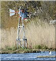
Windmill Oxygenerator, Brooklands Park
One of two added when the park was renovated in 2020 whose job is to pump oxygen into the water.
Image: © Simon Carey Taken: 31 Mar 2024
0.10 miles
8
Boating Lake, Brooklands Park
Excavated in 1958 as part of a new park but also as a flood prevention measure for Teville Stream and its tributaries. This is the view from the southern end where Teville Stream is culverted under the A259 and then enters the sea.
Image: © Simon Carey Taken: 31 Mar 2024
0.10 miles
9
The Quadrant, Marlborough Road, Lancing
Image: © PAUL FARMER Taken: 15 Nov 2022
0.10 miles
10
Boats at Brookland Park
Image: © Paul Gillett Taken: 27 Aug 2009
0.11 miles
  • ...