IMAGES TAKEN NEAR TO
Abbotts View, LANCING, BN15 0NG
Introduction
This page details the photographs taken nearby to Abbotts View, BN15 0NG by members of the Geograph project.
The Geograph project started in 2005 with the aim of publishing, organising and preserving representative images for every square kilometre of Great Britain, Ireland and the Isle of Man.

There are currently over 7.5m images from over14,400 individuals and you can help contribute to the project by visiting https://www.geograph.org.uk
Image Map (Loading...)


Getting Data...Please wait
Leaflet Map data © OpenStreetMap
Images are licensed for reuse under creativecommons.org/licenses/by-sa/2.0
Notes
- Clicking on the map will re-center to the selected point.
- The higher the marker number, the further away the image location is from the centre of the postcode.
Image Listing (33 Images Found)
Images are licensed for reuse under creativecommons.org/licenses/by-sa/2.0
Image
Details
Distance
1
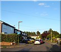
Abbotsview, Sompting
A cul de sac off Halewick lane that was built in the 1960s.
Image: © Simon Carey
Taken: 5 Jul 2020
0.02 miles
2
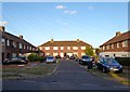
Halewick Close, Sompting
A small cul de sac off Halewick Lane built in the late 1940s.
Image: © Simon Carey
Taken: 5 Jul 2020
0.04 miles
3
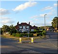
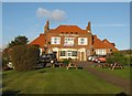
The Joyful Whippet, Steepdown Road, Sompting
Built in the 1960s at the junction of Steepdown Road and Halewick Lane on the site of what was once a chalk quarry. There are currently plans to demolish the pub and replace with housing.
Image: © Simon Carey
Taken: 5 Jul 2020
0.05 miles
4
The Joyful Whippet Sompting
Sandwiched between Steepdown Road and Halewick Lane.
Image: © Dave Spicer
Taken: 29 Nov 2012
0.05 miles
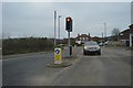
6
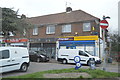
Hillbarn Parade, Sompting
Small parade of four shops located at the junction of Halewick Lane and Upper Brighton Road, the A27. Number three is currently empty but the rest are occupied by a fencing business, a fish and chip shop and a small local store.
Image: © Simon Carey
Taken: 5 Jul 2020
0.06 miles
7
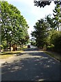
Steepdown Road, Sompting
Heading south from the junction with Valley Road and Sedbury Road towards another with Halewick Lane. Built in the late 1930s.
Image: © Simon Carey
Taken: 12 Jul 2020
0.07 miles
9
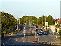
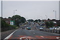
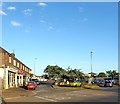
Upper Brighton Road, Sompting
A view of the A27 towards the junction with Halewick lane and Busticle Lane. Originally the main road turned south down Busticle Lane than west along West Street through Sompting. The bypass was built in 1939 as far as Church Lane utilising an old highway called Bullpit Lane then completed after the war.
Image: © Simon Carey
Taken: 5 Jul 2020
0.08 miles