IMAGES TAKEN NEAR TO
Pende Close, LANCING, BN15 0HP
Introduction
This page details the photographs taken nearby to Pende Close, BN15 0HP by members of the Geograph project.
The Geograph project started in 2005 with the aim of publishing, organising and preserving representative images for every square kilometre of Great Britain, Ireland and the Isle of Man.

There are currently over 7.5m images from over14,400 individuals and you can help contribute to the project by visiting https://www.geograph.org.uk
Image Map
Images are licensed for reuse under creativecommons.org/licenses/by-sa/2.0
Notes
- Clicking on the map will re-center to the selected point.
- The higher the marker number, the further away the image location is from the centre of the postcode.
Image Listing (36 Images Found)
Images are licensed for reuse under creativecommons.org/licenses/by-sa/2.0
Image
Details
Distance
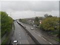
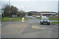
2
The worst day I ever went Geographing (contd page 94)
Taken at the junction of Manor Road and the A27, I was so wet both my cameras packed up; and when I eventually did get on the train at Lancing I dripped a trail of water roughly equivalent to the River Arun down the aisle.
Image: © Basher Eyre
Taken: 2 May 2010
0.03 miles
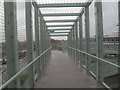
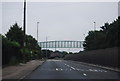
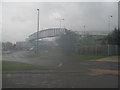
4
Lancing, footbridge
Bridge with stairs and ramps, crossing Upper Brighton Road (A27).
Image: © Mike Faherty
Taken: 18 May 2019
0.03 miles
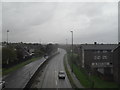
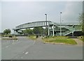
6
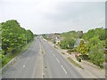
Lancing, Upper Brighton Road
A27, looking towards Sompting from Image
Image: © Mike Faherty
Taken: 18 May 2019
0.03 miles