IMAGES TAKEN NEAR TO
Ditchling Road, BRIGHTON, BN1 4SD
Introduction
This page details the photographs taken nearby to Ditchling Road, BN1 4SD by members of the Geograph project.
The Geograph project started in 2005 with the aim of publishing, organising and preserving representative images for every square kilometre of Great Britain, Ireland and the Isle of Man.

There are currently over 7.5m images from over14,400 individuals and you can help contribute to the project by visiting https://www.geograph.org.uk
Image Map
Images are licensed for reuse under creativecommons.org/licenses/by-sa/2.0
Notes
- Clicking on the map will re-center to the selected point.
- The higher the marker number, the further away the image location is from the centre of the postcode.
Image Listing (417 Images Found)
Images are licensed for reuse under creativecommons.org/licenses/by-sa/2.0
Image
Details
Distance
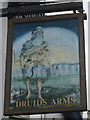
1
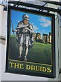
The Druids sign
Compared with previous sign Image
Image: © Oast House Archive
Taken: 5 Nov 2017
0.01 miles
2
Entrance to Open Market
Opposite the Level, The historic Open Market underwent a major redevelopment in 2014 and is now home to over 50 of Brighton’s most talented and knowledgeable local producers and creators.
With a strong focus on fresh nutritious foods and ethical products, the market has a range of traditional market stalls—butcher, fishmonger, eggs, fruit and veg—as well as cafes, art, crafts, fashions, antiques, haberdashery, tools, garden goods and more http://www.brightonopenmarket.co.uk/
Image: © Paul Gillett
Taken: 14 Nov 2014
0.01 miles
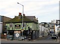
3
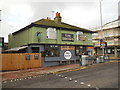
The Druids Pub
Opposite the level in Ditchling Road http://druidspub.com/
Image: © Paul Gillett
Taken: 14 Nov 2014
0.01 miles
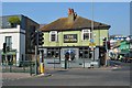
5
The Druids, Ditchling Road, Brighton
Dating from around the 1840s and located on the corner of Image
Image: © Simon Carey
Taken: 25 Oct 2015
0.02 miles
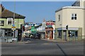
7
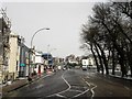
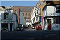
Ditchling Road
The southern end of the road that stretches from The Level to Ditchling Beacon. Originally one of the main London-Brighton routes that was turnpiked in the 1770s with this section developed from the 1810s onwards though it was originally known as Brunswick Terrace North. Beyond the junction with Union Road the road climbs steeply up the slopes of Round Hill and this section became impassable during the previous evening's ice and snow with a fair few abandoned cars still parked further up the following lunchtime. The section between St Peter's Place and Viaduct Road is currently part of the A23 one way system that runs around London Road.
Image: © Simon Carey
Taken: 12 Mar 2013
0.02 miles
9
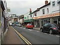
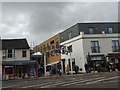
Baker Street, Brighton
Side street in the London Road shopping area
Image: © Paul Gillett
Taken: 29 Jan 2011
0.02 miles