IMAGES TAKEN NEAR TO
Viaduct Road, BRIGHTON, BN1 4NB
Introduction
This page details the photographs taken nearby to Viaduct Road, BN1 4NB by members of the Geograph project.
The Geograph project started in 2005 with the aim of publishing, organising and preserving representative images for every square kilometre of Great Britain, Ireland and the Isle of Man.

There are currently over 7.5m images from over14,400 individuals and you can help contribute to the project by visiting https://www.geograph.org.uk
Image Map
Images are licensed for reuse under creativecommons.org/licenses/by-sa/2.0
Notes
- Clicking on the map will re-center to the selected point.
- The higher the marker number, the further away the image location is from the centre of the postcode.
Image Listing (421 Images Found)
Images are licensed for reuse under creativecommons.org/licenses/by-sa/2.0
Image
Details
Distance
2
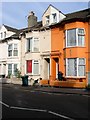
44-45, Viaduct Road, Brighton
The red flag is still flying at number 45. The houses were built in the mid 1840s with many now let to students.
Image: © Simon Carey
Taken: 25 Oct 2015
0.03 miles
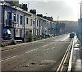
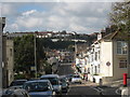
3
Viaduct Road, Brighton
The road runs between Preston Circus and Ditchling Road and was developed in the mid 1840s and was originally known as Montpelier Road East running along the old parish boundary between Brighton to the south and Preston to the north. Later on it became the A27 until the bypass was opened in the early 1990s after which it was designated as the A270 with this stretch also shared by the A23 southbound traffic. The large black plant pots were added in early 2015 as a traffic calming measure to much local derision.
Image: © Simon Carey
Taken: 25 Oct 2015
0.04 miles
4

Rose Hill Tavern, Rose Hill Terrace, Brighton
Opened around 1871 the pub closed in 2014 since when a huge battle has been taking place to prevent it being converted into flats. The building which has changed little over the decades has been granted an asset of community value and in April 2015 the planning application for conversion was rejected by the council. However, the battle is still far from won.
Image: © Simon Carey
Taken: 25 Oct 2015
0.04 miles
5
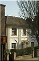
87 London Road, Brighton
Regency period survivor in a busy shopping street. Grade II listed.
Image: © Jim Osley
Taken: 13 Feb 2017
0.04 miles
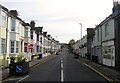
7
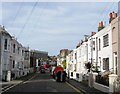
Rose Hill Terrace, Brighton
The road was developed in the early 1850s and originally linked London Road to Ditchling Road. However, bomb damage during the Second World War removed numbers 84-88 on whose site Rose Hill Court was erected in the 1980s effectively splitting the road in two with the eastern section now Image The high rise block in the distance is Vantage Point.
Image: © Simon Carey
Taken: 25 Oct 2015
0.05 miles
8
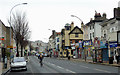
London Road, Brighton
This is the A23 south-east of Preston Circus crossroads.
Image: © Roger D Kidd
Taken: 1 Jan 2015
0.05 miles
9
Rose Hill Terrace
Opposite the junction with London Terrace.
Image: © Simon Carey
Taken: 5 Nov 2006
0.05 miles
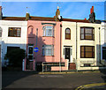
10
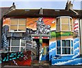
70-71, Viaduct Road, Brighton
At the beginning of 2015 the local council sent letters to all residents in Viaduct Road asking owners to tidy the street up a little. The owner of these two properties along with another on the opposite side of the road, see Image, decided to commission local graffiti artist Aroe MSK to add a bit of colour. The result led council officials to investigate their rule books though no action has yet to be taken possibly because both have proved very popular with locals and those travelling along the A23 into town.
Image: © Simon Carey
Taken: 25 Oct 2015
0.06 miles