IMAGES TAKEN NEAR TO
Belmont Street, BRIGHTON, BN1 4HN
Introduction
This page details the photographs taken nearby to Belmont Street, BN1 4HN by members of the Geograph project.
The Geograph project started in 2005 with the aim of publishing, organising and preserving representative images for every square kilometre of Great Britain, Ireland and the Isle of Man.

There are currently over 7.5m images from over14,400 individuals and you can help contribute to the project by visiting https://www.geograph.org.uk
Image Map
Images are licensed for reuse under creativecommons.org/licenses/by-sa/2.0
Notes
- Clicking on the map will re-center to the selected point.
- The higher the marker number, the further away the image location is from the centre of the postcode.
Image Listing (938 Images Found)
Images are licensed for reuse under creativecommons.org/licenses/by-sa/2.0
Image
Details
Distance
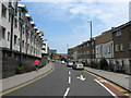
1
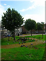
Pigeons, St Peters Street
Small open area for residents of the newly constructed houses in St Peters Street. The wooden sculptures are of whales.
Image: © Simon Carey
Taken: 1 Oct 2006
0.01 miles
2
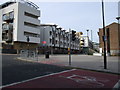
New England Quarter
The New England Quarter is a mixed-use development in the city of Brighton and Hove, England. It was built between 2004 and 2008 on the largest brownfield site in the city, adjacent to Brighton railway station.
More detail: http://en.wikipedia.org/wiki/New_England_Quarter
Image: © Paul Gillett
Taken: 31 Jan 2010
0.02 miles
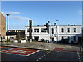
3
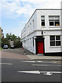
Belmont Street
Built in the 1850s and demolished at the end of the 1960s. this tiny section and buildings on the corner of Cheapside are all what remains.
Image: © Simon Carey
Taken: 31 Jul 2011
0.02 miles
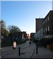
4
Belmont Street, Brighton
The street once ran from Cheapside to Ann Street and was built in the 1850s and demolished in the late 1960s leaving just number 43 standing. See http://regencysociety-jamesgray.com/volume25/source/jg_25_254.html for a view down the street taken in 1967. Beyond is St Bartolomews church.
Image: © Simon Carey
Taken: 25 Oct 2015
0.02 miles
5

Cheapside
A minor back street until the new access road was built as part of the New England Quarter development which turned it into the A270 though it is one way between London Road and the junction of Whitecross Street and New England Street. The Trafalgar Place development built in the late 1980s on the site of the old goods shed is in the distance.
See http://regencysociety-jamesgray.com/volume25/source/jg_25_242.html for a view of the southern side of the street beyond the traffic lights taken prior to clearance in 1962.
Image: © Simon Carey
Taken: 31 Jul 2011
0.02 miles
6
New England Street
Originally the name only applied to the northern part of what was three separate streets. The middle section was New York Street and this part was Fleet Street all packed with terracing housing built in the 1850s to house the workers for the nearby locomotive works. The northern part was demolished in the late 1950s/early 1960s whilst this part went towards the end of the 1960s. To the left was the boundary with the goods yard which had been extended in 1905 but had become a giant car park by the 1980s. The rest was turned into small pockets of housing or office blocks and business premises. The old goods yard was finally redeveloped in the 2000s and with it a new access road to the west which was named Fleet Street leaving this section of New England Street now closed beyond the junction with Ann Street.
Image: © Simon Carey
Taken: 31 Jul 2011
0.02 miles
7
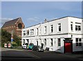
Belmont Street
Little more than a car park for the only remaining buildings left in the street. It once ran from Cheapside to Ann Street but was demolished in the early 1960s along with all the terraced housing in New England Street, now it runs the length of the white building before being blocked by new housing.
Image: © Simon Carey
Taken: 25 Nov 2009
0.03 miles
8

Building on Providence Place
Heavily decorated with Street Art.
Image: © Oliver Dixon
Taken: 11 Sep 2019
0.03 miles
9
St Peter's Street, Brighton
A residential street that connects Ann Street to Cheapside that was originally built in the 1840s but demolished in its entirety during the 1960s. The site remained empty until the 1990s when the northern terrace was built and the southern side left as a small garden.
Image: © Simon Carey
Taken: 21 Nov 2015
0.03 miles
10
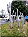
Sculpture in Providence Place
Simple wooden sculpture, resembling the ribs of a boat.
Image: © Oliver Dixon
Taken: 11 Sep 2019
0.03 miles