IMAGES TAKEN NEAR TO
Cheltenham Place, BRIGHTON, BN1 4AB
Introduction
This page details the photographs taken nearby to Cheltenham Place, BN1 4AB by members of the Geograph project.
The Geograph project started in 2005 with the aim of publishing, organising and preserving representative images for every square kilometre of Great Britain, Ireland and the Isle of Man.

There are currently over 7.5m images from over14,400 individuals and you can help contribute to the project by visiting https://www.geograph.org.uk
Image Map
Images are licensed for reuse under creativecommons.org/licenses/by-sa/2.0
Notes
- Clicking on the map will re-center to the selected point.
- The higher the marker number, the further away the image location is from the centre of the postcode.
Image Listing (1179 Images Found)
Images are licensed for reuse under creativecommons.org/licenses/by-sa/2.0
Image
Details
Distance
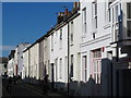
1

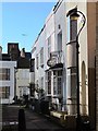
Cheltenham Place, Brighton
A residential street that runs between North Road and Gloucester Road that was developed in the 1840s.
Image: © Simon Carey
Taken: 1 Nov 2015
0.01 miles
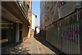
3
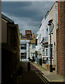
Blenheim Place, Brighton, Sussex
A narrow lane, running between Gloucester Place and Cheltenham Place.
Image: © Peter Trimming
Taken: 16 May 2012
0.01 miles
4
Gloucester Road
Head west up North Road then south down Cheltenham Place then east down Gloucester Road. This right angled turn is at the bottom of the road originally prevented entering the northern edge of the Steine by existing houses. Gloucester Road was built up of small artisans cottages in the 1840s needed by the workers on the railway and industrial concerns in this part of the town.
Click on the link to take you to the next page. http://www.geograph.org.uk/photo/231258
Image: © Simon Carey
Taken: 1 Sep 2006
0.01 miles
5
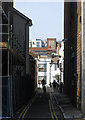
Blenheim Place
Narrow thoroughfare that lies between Gloiucester Place, the A23, and Cheltenham Place. The wall on the right belongs to Image whilst the buildings providing the backdrop are the rear of premises on Queen's Road, the A2010. Vehicular access is only available for half of the street, the rest is pedestrianised.
Image: © Simon Carey
Taken: 25 Sep 2011
0.02 miles
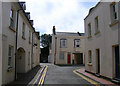
8

Cheltenham Place
Small side street linking North Road to Gloucester Road built in the 1840s and still retaining very small front gardens which is rare for this part of Brighton. The building on the right is a small printing works whilst the arrow chalked onto the street is pointing towards a small yard sale.
Image: © Simon Carey
Taken: 31 Jul 2011
0.03 miles
9
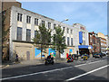
Astoria Cinema
A former purpose built cinema that opened in 1933 and closed in 1977, becoming a bingo hall until that venture ended in 1997. The first floor was used for a while as a keep fit/dance studio but the building has largely been empty for the last decade as a series of plans for conversion have failed to take off. It was finally announced last week that the council have given planning permission to demolish the structure and build a new set of offices on the site.
Image: © Simon Carey
Taken: 25 Sep 2011
0.03 miles
10
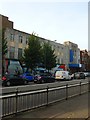
Former Astoria Cinema, Gloucester Place, Brighton
Four years on from Image and not much has changed.
A former purpose built cinema that opened in 1933 and closed in 1977, becoming a bingo hall until that venture ended in 1997. The first floor was used for a while as a keep fit/dance studio but the building has largely been empty for the last decade as a series of plans for conversion have failed to take off. The battle has been over whether to demolish the building or not. It was listed in 2000 and eventually required assent from the Government's Communities Secretary in 2012 to proceed with the demolition. Since then there has been the question what to do with the site with proposals for flats and offices coming to nothing. However, in 2015 permission was granted by the council to turn the site into student housing.
Image: © Simon Carey
Taken: 4 Oct 2015
0.03 miles