IMAGES TAKEN NEAR TO
Dominion Road, WORTHING, BN14 8JW
Introduction
This page details the photographs taken nearby to Dominion Road, BN14 8JW by members of the Geograph project.
The Geograph project started in 2005 with the aim of publishing, organising and preserving representative images for every square kilometre of Great Britain, Ireland and the Isle of Man.

There are currently over 7.5m images from over14,400 individuals and you can help contribute to the project by visiting https://www.geograph.org.uk
Image Map
Images are licensed for reuse under creativecommons.org/licenses/by-sa/2.0
Notes
- Clicking on the map will re-center to the selected point.
- The higher the marker number, the further away the image location is from the centre of the postcode.
Image Listing (34 Images Found)
Images are licensed for reuse under creativecommons.org/licenses/by-sa/2.0
Image
Details
Distance
1
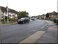
Southdownview Road, Worthing
The road links Penfold Road to Dominion Road, the B2223. Much of its western side is residential whereas the eastern side is largely made up of trading estates.
Image: © Simon Carey
Taken: 31 Mar 2024
0.08 miles
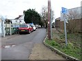
2
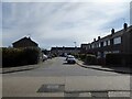
Russell Close, Worthing
A cul de sac off Harrison Road developed in the 1960s.
Image: © Simon Carey
Taken: 31 Mar 2024
0.09 miles
3
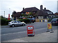
The Dolphin, Dominion Road
Viewed from Angola Road.
Image: © Peter Holmes
Taken: 23 Sep 2008
0.10 miles
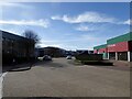
4
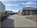
Decoy Road, Wigmore Trading Estate, Worthing
Developed from the late 1980s onwards on a former football ground belonging to Wigmore Athletic who had merged with another local side Southdown to become Worthing United in 1988. The club are currently at step 10 of the football period and now play at Beeches Avenue to the north of the A27. Two of Worthing United's players were killed in the 2015 Shoreham Air Disaster on their way to play in a fixture.
Image: © Simon Carey
Taken: 31 Mar 2024
0.12 miles
5
Harrison Road, BN14 8LT
Restricted byway 3733 to Dominion Way.
Image: © Peter Holmes
Taken: 10 Jan 2017
0.12 miles
6
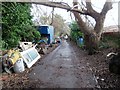
Harrison Road, BN14 8LT
Restricted byway 3733 to Dominion Way.
Image: © Peter Holmes
Taken: 10 Jan 2017
0.13 miles
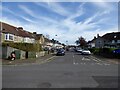
7
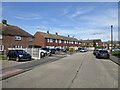
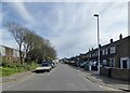
Harrison Road, Worthing
A residential road linking Dominion Road, the B2223, with Southdownview Road. Beyond the latter it continues as a restricted byway to Dominion Way. The road first appears on the 1909 OS map and had acquired its current name by the 1930s, however, it was only developed at the western end adjacent to the junction with the B2223 and mainly provided access to a number of nurseries. Much of the current housing only appeared during the 1960s.
Image: © Simon Carey
Taken: 31 Mar 2024
0.15 miles
8
Hazelwood Close, East Worthing Trading Estate, Worthing
A cul de sac off Dominion Way developed in the late 1970s.
Image: © Simon Carey
Taken: 31 Mar 2024
0.15 miles
9
Marlowe Road, Broadwater, Worthing
A residential road linking Beaumont Road to Congreive Road. This section is located between the latter and Sheridan Road and was developed in the 1930s.
Image: © Simon Carey
Taken: 31 Mar 2024
0.16 miles